While rummaging around in my picture collection recently, I found four lantern slides of the Upper West Side elevated railway showing it under construction in 1879. They're pretty dirty, and I am sure they were not made from original negatives but rather by photographing other photographs. The sharpest exposure is usually in a circular area near the center.
The two elevated companies— New York Elevated Railroad and Metropolitan Elevated Railway— had both been awarded franchises for Ninth Ave (Columbus Ave). The Metropolitan company could not continue their Sixth Ave El directly north because of Central Park, and Seventh Ave was likewise unusable, and Eighth Ave was not allowed because of popular sentiment against an elevated railway running right next to the park, thus pushing any possible Sixth Ave extension all the way west to Ninth Ave. Under an agreement New York Elevated built up to 83rd St, and briefly considered some alternate routing north from there. Metropolitan Elevated constructed the rest up to 155th St. The main service in the nineteenth century was by Sixth Ave trains. Older New Yorkers who remember the line, which closed in 1940, invariably consider it part of the Ninth Ave El, which was the main service in its last years.

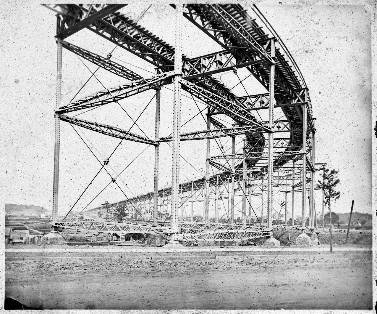
110th St, looking from Eighth Ave west toward Ninth Ave.
Other photos from this general location were in Riding the El part 13. There were few buildings in this area in 1879, so we can see clearly up to the higher ground at Ninth Ave (Columbus Ave). The downgrade at track level was made less steep by erecting a very high structure here and letting it slope gradually down to a normal height at about 125th St.

A detail shows the foundations of the columns. These look the same as those in a diagram published in 1878, for an article explaining that they have a concrete footing, over which is a cut stone core that the column rests on, surrounded by brick. I wonder how many of these foundations remain out of sight under the streets. They are so solid, probably only those in the way of other work would have been removed.
You can also see the trees on the rocky hillside leading up to Ninth Ave. All this is covered now by apartment blocks. This photograph appears in The First Elevated Railroads in Manhattan and the Bronx by William Fullerton Reeves (New-York Historical Society, 1936), and in his caption he writes, "In the distance, at the left, Lion Park is shown, located at 109th Street, east side of Ninth Avenue."
Lion Park and the Lion Brewery was actually between 107th St and 108th St, as shown in this excerpt below from G W Bromley's Atlas of the Entire City of New York published the same year as the photograph, 1879.

Neighborhood trivia. Look at that "Cemetery" at the corner of 109th St. This was too late a date for a planned new cemetery in Manhattan, so I don't know what to think. What did they do with the bodies? At the upper left, Leake and Watt's Orphan Asylum would become the grounds for the Cathedral of St John the Divine, and part of the orphanage's main building is still standing, attached to the cathedral.

Construction workers look down at the photographer. The tubular Phoenix column was favored by the Metropolitan Elevated company. It is made of four parts bolted together.
Eighth Ave, looking north from 110th St.
This perspective, blocked later by buildings, shows very nicely how the track grade slopes gradually down to a normal height.

Up on the structure is the beginnings of 116th St station, but the long stairway that led to the street is not visible and may not have been built yet.
The shanty at ground level may have nothing to do with the construction. Such primitive houses can be seen in many photographs of upper Manhattan in the nineteenth century.

This thing amazed people in 1879, and it still amazes me now.
The cross-beams have hangers for possible center track, which was added within fifteen years.

Ninth Ave (Columbus Ave).
A short section at this location was originally built for three tracks.
But what is this location? This photograph is also in Reeves, who writes, "Looking northwest from 96th St. Remains of the old Croton Aqueduct (built 1842) are visible at the extreme left." However the lantern slide itself has a handwritten note, "100th St & 9th Av before woodwork".
Referring again to Bromley's 1879 atlas, 100th St wins. There was a cluster of buildings at 100th St, but none at 96th St.

Apparently the aqueduct originally ran above ground level in this area. The right of way can be seen as a pair of wider lots through each block (where I have inserted the letters ST for each street name). I'll come back to this in a few moments.

Houses at 100th St. On the left is a pile of wooden cross-ties waiting to be hoisted up to the structure.

Details of the ironwork.
Back to the aqueduct. Now here is something I never heard of before. The Clendinning Valley.
This valley is 1900 feet across, and the Aqueduct is supported upon a foundation wall of dry stone work having the face laid in mortar, except over three streets where bridges are built, having an arch of 30 feet span for the carriage-way and one on each side of 10½ feet span for the sidewalks. These bridges are over 98th, 99th, and 100th streets. [...] These bridges are beautiful specimens of mechanical work ; indeed the whole structure across this valley has a degree of neatness, finish, and taste, not surpassed by any on the line of Aqueduct.The book quoted here, Illustrations of the Croton Aqueduct by Fayette Bartholomew Tower, 1842, contains not one but two images of this wonder, by the author.


That is Manhattan around 100th St in 1842! The viaduct extended from 95th St to 102nd St. Originally there was to be an arch at every street ; but then to save money it was proposed to build a solid wall seven blocks long ; and then to compromise with irate city officials, in the final plan three streets were allowed through. 96th St was not one of them. The whole thing was torn down in the 1870s, replaced by a siphon running under Ninth Ave.
As little as it shows, the photograph above may be the only photograph of any part of the Clendinning aqueduct. There, now I've said that, someone will want to prove me wrong.

The handwritten note on this slide says "8th Av from 116th St looking North". The point of view is probably 115th St looking north, with 116th St the first cross street we see there. From that point back, for a distance, are cross beams to support the station platform, which was not yet built.
You can imagine why real estate speculators were enthusiastically behind construction of elevated railways. These nearly empty properties suddenly became useful places for commuters once there was a reasonably fast way to get downtown. The cluster of buildings in the distance were around 125th St, which had a crosstown streetcar connecting to the Harlem Railroad at Park Ave for trains to Grand Central. But this elevated railway would take you directly to lower Manhattan for one fare (originally ten cents). Progress. No more cows at 100th St.
These are some great old slides. It's hard to believe this is New York considering how built up with Upper West Side apartments the area is. How times have changed!
ReplyDelete