Showing posts sorted by date for query east harlem. Sort by relevance Show all posts

Sunday, December 11, 2011

Danbury Railways revised


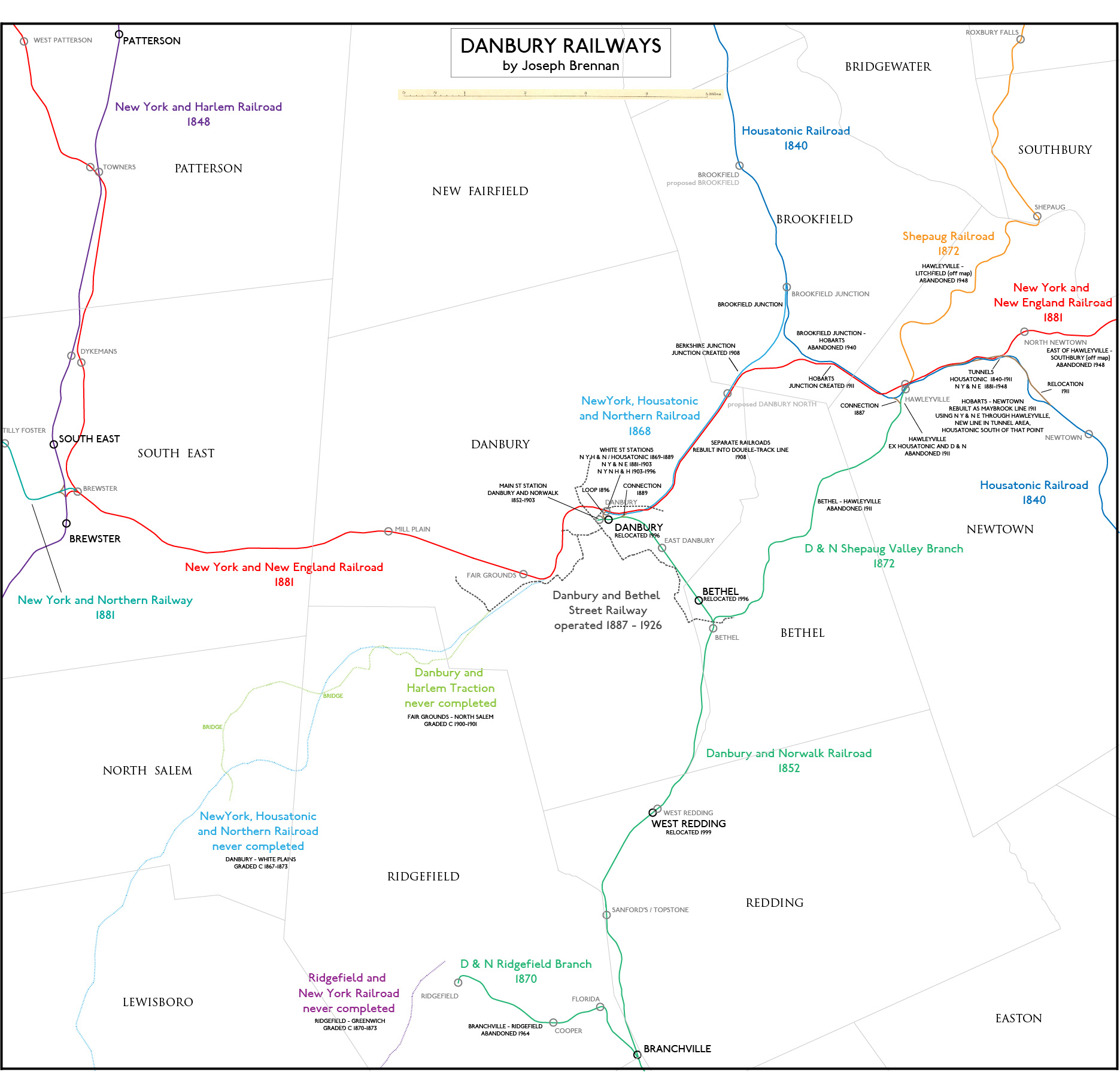
Last week we had an historical map of railways around Danbury, Connecticut, and I said, why not?

This week I say: Why not do it better?

Sometimes I can't let go of something when I know I didn't quite finish it. So I blew another 12 hours or so crossing the I's and dotting the T's.

First of all, the jpg map was awful. Here are much better ones, a big PDF with the topo map background and a smaller clean JPG without.


Besides an improved appearance, these maps also have various corrections and additions. Most notably, I added a strip on the west side where I had just barely cut off the interesting area around Brewster, and I added two more partially constructed railways.

Secondly, I rewrote the Historical Sketch section into better English style, and added more details. I can write good. Or write well. Whichever.

The result so far is semi permanently enshrined at http://www.columbia.edu/~brennan/danbury/.

I was especially surprised to learn that there were three partially constructed railways in the area. I had the New York, Housatonic and Northern last week, but now I've added the Ridgefield and New York and the Danbury and Harlem Traction line. These more than pipe dreams. All three companies purchased and graded many miles of property, leaving traces that can still be seen today.

As I mentioned last time, the NYH&N actually opened the small portion from Danbury to Brookfield Junction, which is still in operation today, and the company also graded another 23 miles (!) that was never operated, far into Westchester County. The Ridgefield and New York similarly graded all or most of its route down to East Port Chester (across the boundary river from Port Chester NY). The trolley line D&HT not only graded part of its route but actually laid about five miles of track and made a test run with a trolley borrowed from the Danbury and Bethel Street Railway.

Local railfans and history buffs have discussed the grades— here is a good one about the D&HT grade, although read carefully because it also references the R&NY grade and mentions the NYH&N.

I made two real finds at the U Conn MAGIC web site, the library's wonderful acronym for the Map and Geographical Information Center. They have a 1934 aerial photography set of the entire state that shows the Danbury and Harlem Traction grade very clearly. They also have almost all of the New Haven railroad valuation maps of 1915, providing enormous detail on the railroad's property and structures at that time, which was about its maximum extent.

The valuation maps, amazingly, include the entire Ridgefield and New York line from Danbury to East Port Chester, even though it was never completed. Notations show that the property from Ridgefield south was sold to the New Haven in 1906. The Ridgefield to Danbury section, which was added to the proposed road some time in the 1880s, is carefully detailed, but why is unclear, because the notes emphasize that the New Haven did not own the property.

Last time Charlie Warren commented that the New York, Westchester and Boston project included a proposed line to Danbury. I know that it was to have continued north from White Plains along a route very similar to that of the unbuilt New York, Housatonic and Northern. I haven't shown it since no work was done. However the New Haven's strange acquisition of the Ridgefield and New York property makes me wonder whether there was any idea of extending the NYW&B from its Port Chester terminal by that route to Danbury. It was already graded after all, although it would probably have needed extensive rebuilding to eliminate grade crossings and live up to the NYW&B standard.

I came across this amusing article about a property for sale in northwestern Greenwich, left over from the New York, Housatonic and Northern project. From the street you see a narrow lot (by local standards) 100 feet wide with a modest house on it, but... the property goes back almost half a mile! Type 56 locust road greenwich ct on Google maps.


.


Sunday, July 17, 2011

South Ferry III


In South Ferry I, we looked at the first elevated railway station at South Ferry, and in South Ferry II, we considered how New York Elevated managed to operate two lines out of the tiny two-track terminal. Now, we'll see when the better-known four-track terminal was built. This larger terminal lasted until 1950.

The Park Commissioners yesterday granted the privilege to the New-York Elevated Railroad Company to build a "Y" on the Battery, to connect with Pier No. 1, North River.

That's the Tribune reporting inaccurately on a significant event on July 3, 1878. This was the official permission to build a very short branch line not at Battery Place but at Whitehall Street. The Parks Department was not part of the city government, but a fairly independent body similar to the public authorities today. The Parks Department had jurisdiction over parks and also some public streets near parks. It appears from subsequent events that Whitehall Street, alongside Battery Park, was one of those streets.

The permission predates the opening of the Third Avenue El by a month and a half, but the company did not follow up immediately, forcing use of the inadequate old station.

The Third Avenue El was extended to 89th Street on December 9, and the papers described planned rush hour headways of two minutes from South Ferry. This could only have been done by turning some trains at the recently installed third track south of Franklin Square. A company spokesman said now that they would build a terminal at 129th Street and that "a similar station will be erected at South Ferry". Service to the end of the line at 129th Street began on December 30.


Bromley's Atlas of the Entire City of New York, dated 1879, above, shows the location of the buildings at South Ferry. The elevated terminal was sited along the west side of the ferry plaza. This may have been done to keep clear the space in front of the South Ferry ferry terminal, but I think even more likely it was done to make the elevated station as long as possible to accommodate Third Avenue trains of four or five cars. The station house is along the west side of the big ferry terminal, not in front of it, getting another car length or so for the station platforms.

Let's get a good look at the scene. The first three images below, from stereo views, are from unknown dates in the 1870s or even 1860s before the elevated railway was built.


A view from the water shows the South Ferry terminal. The map above and the name on the arch agree that the boat on the left is handling the Hamilton Ferry, and the empty slip on the right is for the South Ferry to Atlantic Avenue.


This view from over the Staten Island ferry building shows where the elevated terminal would be built, along the left side of the South Ferry building and along the edge of Battery Park.


Turning around, we see the front of the South Ferry terminal. Look closely and you can see the names South Ferry and Hamilton Ferry on each side. I wonder what colors this amazing building was painted! The elevated terminal would be built along the edge of the park and extending into the space to the right of the ferry terminal.


A detail of the cabinet card from South Ferry I looks down the edge of the park, where we can see the shacks serving as Staten Island ferry terminals.


Construction for the big terminal must have begun around December 3. That's when the political grandstanding about encroachment on the park started.

The Tribune described the work in an article of December 19:

The plaza near the South and Staten Island Ferries has now a very disorderly appearance, owing to the preparations of the Elevated Railroad Company to extend its tracks over a portion of it. Heaps of earth, stones and logs lie scattered about, while here and there laborers are engaged making excavations for the foundations of pillars. Pumping engines are required to keep several of the holes free from water, which flows in at high tide. In order to secure any foundation, the railroad company's engineers have been compelled to drive long wooden piles into the bottom of the holes. Besides excavating holes in the plaza, the railroad company is digging others in Battery Park. ... When all the tracks are completed the company will be able to dispatch trains with far more frequency than at present. A handsome new depot will also be constructed on the south side of the plaza.

Further progress was reported on January 31:

Work on the station and tracks at South Ferry is advancing, and it is thought that in a month trains will start from that point on a one-minute headway. ... The road is carrying an average of 90,000 passengers a day.

It took more than a month. A report of March 7:

The terminus in Whitehall-st is so far completed that ties are being put in place ; before it can be used and the old structure in Battery Park removed, the new station adjoining Staten Island Ferry will have to be built. With the arrangements completed at this point a train may start out on each side as one arrives.

That means "the old station in Battery Park removed". I'm surprised to read that they were up to laying ties on the new terminal trackways when they had not yet even started building the station house.

The opening of the City Hall branch (joining the main line at Chatham Square) on March 17 provided some relief. Rush hour headways became: South Ferry to Harlem 4 minutes, South Ferry to Grand Central 6 minutes, Franklin Square to Harlem 8 minutes, and City Hall to Harlem 4 minutes. Do the math: that's 47½ trains per hour in one direction on the main trunk between Chatham Square and 42nd Street.

Trains crossed at grade going in and out of the branches at Chatham Square and 42nd Street. New York Elevated's management didn't believe in interlocking systems and ran everything with flagmen. At 42nd Street, trains going uptown to Grand Central every 6 minutes crossed trains going downtown less than 1½ minutes apart. What could happen? A side-swipe collision there on March 25 put an end to this schedule after only eight days. Both branches were immediately closed, and on March 27 the company announced that platforms would be built at the junctions so that the branches would be worked only with shuttle trains.

On this occasion Company President Cyrus Field provided a clue to the opening date of the terminal at South Ferry:

Mr Field thought this determination necessary, as trains will be run from South Ferry in a day or two at one minute intervals, and then the danger at the cross tracks would be very great, as the trains at Chatham-square would not be more than a half-minute apart.

You would expect a news article would follow describing the wonderful new terminal at South Ferry, which may have opened on the weekend of March 29 and 30, or Monday March 31. But I have not been able to find one.

I do have an article in the Tribune for April 11 that mentions that the Third Avenue El was then operating 62 trains an hour in one direction in rush hours. This scarcely seems possible with a two-track terminal at South Ferry, but it is certainly impossible without it. Of the 62, some probably ran from Franklin Square. It's still astounding.

And let's look at the new terminal. The three images below are early, possibly close to opening day.


I think this first one is a great image. You can see the same Staten Island ferry shacks on the right, with a stairway direct from the elevated station. Toward the left, under the el, you can see the South Ferry terminal too. Compare it to the views up above.

This image might show Third Avenue cars and pre-1880 Ninth Avenue cars together. The car farther back is a 1878 Third Avenue car built by Gilbert and Bush, with pointed arches over the window— for transit geeks, it's the same type as Car G, which still exists, and might possibly even be Car G although that's impossible to determine. The closer car, far left, is at the Ninth Avenue line platform, and although the roof silhouette is consistent with the narrow pre-1880 cars, I don't think it's clear enough to say for sure. If it is though, then this image is no later than May 1880.


This stereo view seems to be from around the same time as the cabinet card. The ladder on the elevated station and the materials in the street make me wonder whether the elevated station has just opened, and some work restoring the street plaza is just being finished.


Around the other side, we can see the corner of the South Ferry building on the left.

This is a Third Avenue train, with the other type of 1878 Third Avenue cars, built by Wason, without the pointed arches. Both types had an oval on the side at the center of the car.

You can see steam from the engine that brought this train in, trapped at the end of track. When the train is pulled out by another engine, this one will follow it out to a point past the switches, where it will wait to move in to take another train out.


The site of the original station from 1877 became part of a track not used for passenger service but useful as the only connection between the east side and west side elevated lines. Two images from Charles Warren's pages show the connection.


This scene is looking west toward Battery Park, with the big South Ferry station to the left. An engine is ready to take out a Third Avenue train. The white pole toward the right is at about the location of the stairway up to the original station. The trees inside the triangle are in photographs of the old station.


This is a later view. The departing Third Avenue train is running across the site of the original station. As we saw in South Ferry I, the station stairs were on the sidewalk under the tower seen here, and the platform extended to the left of that point. There is only one connecting track, on the near side of the tower.

Third Avenue engines ran with the engine on the downtown side, while Ninth Avenue engines did the opposite— so an engine running through the connection to the other line was oriented correctly.

The old South Ferry terminal is still standing here, but there is something in front of it that may be an elevated walkway. The building on the right was built by the United States for the Barge Office and the Immigration service.


The Second Avenue and Sixth Avenue Els began running to South Ferry in 1880 and 1881 respectively. Paths for these additional trains were made by routing some East Side trains to City Hall and terminating some West Side trains at Rector Street.

The terminal was expanded by 1910 with longer platforms and side platforms. The Sixth Avenue El closed in 1938, and after the Ninth Avenue El closed in 1940, the west side of the South Ferry terminal was demolished. The Second Avenue El closed in 1942, and in 1950 Third Avenue El service from Chatham Square to South Ferry was eliminated. After that the remainder of the terminal was removed. Nothing of it can be seen today. Even the path of the West Side elevated in Battery Park has been obliterated by redesign, and Front Street, over which the East Side lines approached, has been closed and built over.

The Staten Island boats were shifted to the site of the former Brooklyn ferries early in the 20th century, and new terminals for them were completed in 1909, then 1956, and most recently 2005.


.

Sunday, May 22, 2011

Lantern Slides : Upper West Side El


While rummaging around in my picture collection recently, I found four lantern slides of the Upper West Side elevated railway showing it under construction in 1879. They're pretty dirty, and I am sure they were not made from original negatives but rather by photographing other photographs. The sharpest exposure is usually in a circular area near the center.

The two elevated companies— New York Elevated Railroad and Metropolitan Elevated Railway— had both been awarded franchises for Ninth Ave (Columbus Ave). The Metropolitan company could not continue their Sixth Ave El directly north because of Central Park, and Seventh Ave was likewise unusable, and Eighth Ave was not allowed because of popular sentiment against an elevated railway running right next to the park, thus pushing any possible Sixth Ave extension all the way west to Ninth Ave. Under an agreement New York Elevated built up to 83rd St, and briefly considered some alternate routing north from there. Metropolitan Elevated constructed the rest up to 155th St. The main service in the nineteenth century was by Sixth Ave trains. Older New Yorkers who remember the line, which closed in 1940, invariably consider it part of the Ninth Ave El, which was the main service in its last years.


110th St, looking from Eighth Ave west toward Ninth Ave.

Other photos from this general location were in Riding the El part 13. There were few buildings in this area in 1879, so we can see clearly up to the higher ground at Ninth Ave (Columbus Ave). The downgrade at track level was made less steep by erecting a very high structure here and letting it slope gradually down to a normal height at about 125th St.


A detail shows the foundations of the columns. These look the same as those in a diagram published in 1878, for an article explaining that they have a concrete footing, over which is a cut stone core that the column rests on, surrounded by brick. I wonder how many of these foundations remain out of sight under the streets. They are so solid, probably only those in the way of other work would have been removed.

You can also see the trees on the rocky hillside leading up to Ninth Ave. All this is covered now by apartment blocks. This photograph appears in The First Elevated Railroads in Manhattan and the Bronx by William Fullerton Reeves (New-York Historical Society, 1936), and in his caption he writes, "In the distance, at the left, Lion Park is shown, located at 109th Street, east side of Ninth Avenue."

Lion Park and the Lion Brewery was actually between 107th St and 108th St, as shown in this excerpt below from G W Bromley's Atlas of the Entire City of New York published the same year as the photograph, 1879.


Neighborhood trivia. Look at that "Cemetery" at the corner of 109th St. This was too late a date for a planned new cemetery in Manhattan, so I don't know what to think. What did they do with the bodies? At the upper left, Leake and Watt's Orphan Asylum would become the grounds for the Cathedral of St John the Divine, and part of the orphanage's main building is still standing, attached to the cathedral.


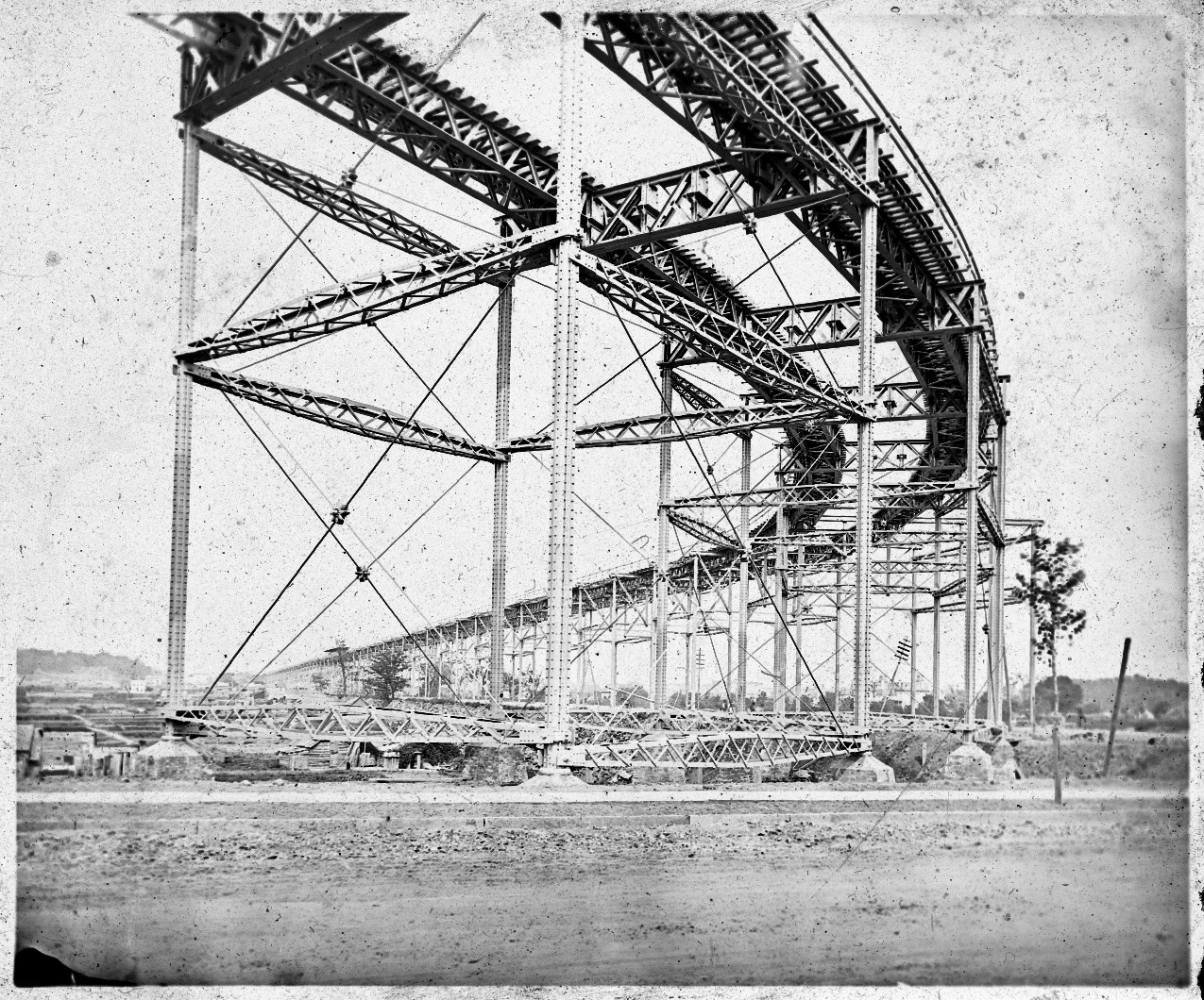
Construction workers look down at the photographer. The tubular Phoenix column was favored by the Metropolitan Elevated company. It is made of four parts bolted together.


Eighth Ave, looking north from 110th St.

This perspective, blocked later by buildings, shows very nicely how the track grade slopes gradually down to a normal height.


Up on the structure is the beginnings of 116th St station, but the long stairway that led to the street is not visible and may not have been built yet.

The shanty at ground level may have nothing to do with the construction. Such primitive houses can be seen in many photographs of upper Manhattan in the nineteenth century.


This thing amazed people in 1879, and it still amazes me now.

The cross-beams have hangers for possible center track, which was added within fifteen years.


Ninth Ave (Columbus Ave).

A short section at this location was originally built for three tracks.

But what is this location? This photograph is also in Reeves, who writes, "Looking northwest from 96th St. Remains of the old Croton Aqueduct (built 1842) are visible at the extreme left." However the lantern slide itself has a handwritten note, "100th St & 9th Av before woodwork".

Referring again to Bromley's 1879 atlas, 100th St wins. There was a cluster of buildings at 100th St, but none at 96th St.


Apparently the aqueduct originally ran above ground level in this area. The right of way can be seen as a pair of wider lots through each block (where I have inserted the letters ST for each street name). I'll come back to this in a few moments.


Houses at 100th St. On the left is a pile of wooden cross-ties waiting to be hoisted up to the structure.


Details of the ironwork.


Back to the aqueduct. Now here is something I never heard of before. The Clendinning Valley.
This valley is 1900 feet across, and the Aqueduct is supported upon a foundation wall of dry stone work having the face laid in mortar, except over three streets where bridges are built, having an arch of 30 feet span for the carriage-way and one on each side of 10½ feet span for the sidewalks. These bridges are over 98th, 99th, and 100th streets. [...] These bridges are beautiful specimens of mechanical work ; indeed the whole structure across this valley has a degree of neatness, finish, and taste, not surpassed by any on the line of Aqueduct.
The book quoted here, Illustrations of the Croton Aqueduct by Fayette Bartholomew Tower, 1842, contains not one but two images of this wonder, by the author.


That is Manhattan around 100th St in 1842! The viaduct extended from 95th St to 102nd St. Originally there was to be an arch at every street ; but then to save money it was proposed to build a solid wall seven blocks long ; and then to compromise with irate city officials, in the final plan three streets were allowed through. 96th St was not one of them. The whole thing was torn down in the 1870s, replaced by a siphon running under Ninth Ave.

As little as it shows, the photograph above may be the only photograph of any part of the Clendinning aqueduct. There, now I've said that, someone will want to prove me wrong.


The handwritten note on this slide says "8th Av from 116th St looking North". The point of view is probably 115th St looking north, with 116th St the first cross street we see there. From that point back, for a distance, are cross beams to support the station platform, which was not yet built.

You can imagine why real estate speculators were enthusiastically behind construction of elevated railways. These nearly empty properties suddenly became useful places for commuters once there was a reasonably fast way to get downtown. The cluster of buildings in the distance were around 125th St, which had a crosstown streetcar connecting to the Harlem Railroad at Park Ave for trains to Grand Central. But this elevated railway would take you directly to lower Manhattan for one fare (originally ten cents). Progress. No more cows at 100th St.


Sunday, February 20, 2011

Riding the El - 12 - Second Avenue


We're going to the Bronx on the Second Avenue El, about May 1940.


137-3. Second Avenue El sign.

The Second Avenue El ran to the Bronx only in rush hours. There were two services: express to Bronx Park via the Third Avenue (Bronx) El, and express to Freeman St via the elevated subway line in Westchester Ave and Southern Blvd. The former supplemented Third Avenue El service and the latter supplemented subway service.


The routing in the south Bronx was peculiar in that it did not run over streets. The reason was that the Bronx system was begun in the early 1880s by a company that planned to build entirely on private right of way. Suburban Rapid Transit bought land and began construction as far as 143rd St. However even while doing so, the directors formed and merged another company that obtained permission to build a more conventional elevated railway over Third Ave. The result in the end was that the Third Ave El left Third Ave at 129th St only to return to it about fifteen blocks farther north in the Bronx.

In hopes of clarifying this, I'm inserting below part a Hagstrom street map of the Bronx dated 1943. The elevated lines are shown as solid black lines.


From the bottom, the Second Avenue Bridge is noted as ELEV R R BR. Notice from there how the line swings over the New Haven freight yard and then turns north running halfway between Alexander Ave and Willis Ave. At 143rd St was a planned junction in the original Suburban Rapid Transit route. The west branch was used in 1887 to bring the line into Third Ave, and the east branch was finally used in 1917 for a new link partly over Bergen Ave to connect with the elevated subway line. If you follow the red subway line from there you will get to the Freeman St station where Second Ave trains terminated.


135-5. Second Ave north from 125th St station.

This a repeat from Riding the El - 11. This time we will ride up the ramp to the upper level of the bridge on an express to Freeman St.


136-1. Second Ave El approaching Second Ave Bridge.

Photo 137-5 in Riding the El - 11 was a similar view from the lower level. It showed the same little train yard on the east side of the structure. Here we can see that the derricks are not for the elevated railway but for The Clark and Wilkins Company's wood yard.

On the left are the tops of buildings in the 129th St elevated railway property.


136-1 detail.

Clark and Wilkins had a very short railway line from the edge of the water, with four-wheeled carts, possibly pushed by hand. You can see a couple of carts there with very evenly cut logs like the ones stacked behind their fence.


136-1 detail.

Beyond the derricks we can see a seven-car express train on the upper level of the elevated railway in the Bronx. Below that is the New Haven Railroad freight yard, and some barges (not car floats) in the Harlem River.


136-2. Second Ave El approaching Second Ave Bridge.

The Third Ave El express track joins from the left.

Ruppert Beer was once a major New York brand. Its second owner, Jacob Ruppert, is best known for owning the New York Yankees from 1924 to 1939. Also promoting themselves in the Bronx by large signs are the Arctic Hygeia Ice Manufacturing Company and Mathushek Pianos.


137-1. Second Ave Bridge looking south.

If we now ran quickly through the crowded rush hour train, we might be able to get this view out the back. On the left is the ramp down to the Second Ave line, and 125th St station is just about in view. The track curving to the right leads to the Third Ave El express track over 129th St station.


137-2. Station on private right of way, 133rd St or 138th St or 143rd St.

The sign directs passengers downstairs for the street and local trains. The Third Ave El ran a full-time service to the Bronx on the lower level, and Second Ave express trains to the Bronx Third Ave El also took the lower level.

The upper level on the private right of way was used only for rush hour trains. The Second Avenue El's Freeman St express trains were stored along this stretch the rest of the time, as seen here. These are Composite cars, the original equipment of the subway when it opened in 1904. They had wooden bodies with copper sheathing that was indented to look like wood slats.

The Composites weighed more than the other el cars, and were allowed to run in passenger service only on portions that had been built or rebuilt in the 20th century. That ruled out almost anything besides express trains. For example the Second Ave express to Freeman St ran on: the completely rebuilt City Hall branch of 1915, Second Ave third track installed in 1915 on new girders, the replacement Second Ave Bridge of 1917, the rebuilt portion on private right of way of 1917, the new Bergen St link of 1917, and the elevated subway line of 1905. The cars were allowed to run empty in the opposite direction on the Second Ave local tracks from 1880.


136-3. Willis Ave looking north at 147th St.

The Hagstrom map (above) is slightly incorrect about the route of the so-called Bergen St Cut. The line left private property at 145th St and ran north over Willis Ave for two blocks. The view above shows where the el then turns into Bergen Ave. Straight ahead is the Third Ave El station at 149th St.


136-3 detail.

There are a lot of people waiting for uptown trains at 149th St station, in the evening rush hour. The six points of Third Ave, Willis Ave, and 149th St was long called "The Hub", and some of the people may be leaving work in the area. Others have probably used the transfer from the subway and want to continue on the el.

Two Third Avenue Railway System trolleys are in the inky shadows under the station. And you might be able to spot the subway stairs with a globe on a pole on each side.


136-4. Westchester Ave looking northeast from Brook Ave.

You can see almost this same scene today. The two tracks coming up on the far left and right are still in use for subway routes 2 and 5. This is right after the subway comes up from underground, where it turns into the elevated line running over Westchester Ave. You can still see support girders for the elevated connection between the subway tracks.

The Bergen St elevated link ran directly over the subway where it comes out, and eagle eyed riders may notice the cut-off elevated columns embedded in the concrete side walls of the cut.

At the bottom of this view are switches for the original elevated connection that ran from Third Ave at Westchester Ave. It was no longer in passenger service in 1940 but still in place (the Hagstrom map does not show it). The Bergen St connection was built solely to avoid congestion at the level junction and the 149th St station.


136-7. Second Ave Bridge looking south.

We're returning to Manhattan on the lower level. The position of the switch shows that we will turn right into the 129th St station rather than run straight into the Second Ave line (which only morning Second Ave express trains would do). The other switch on the left is set for a Second Ave train to run north, meaning one just passed or is just about to come into view.

Near the bottom of the image is the end of the draw. The portion we are on could swing 90 degrees to allow a tall ship to pass up the Harlem River.


136-8. 129th St station looking west.

Same train. We have come around the curve and see 129th St station. The single express track for Third Ave Through Express trains passes overhead with no station platform.


136-8 detail.

The platform on the right was not used in passenger service. The far right track ends at a bumper.

The platform on the left was used for Third Ave trains running to and from the Bronx. The full-time service was by local trains, with rush hour express service by Local Express, a nomenclature that meant they ran express in Manhattan up to 125th St and then local in the Bronx. Through Express trains continued to skip local stations for some distance in the Bronx.

To the left of that was the Third Ave terminal platform, for some rush hour trains that ended here, and finally to the left of that was the Second Ave terminal platform.


And we'll stop here.

Sunday, February 13, 2011

Riding the El - 11 - Second Avenue


Last time we went uptown on the Second Avenue El to 125th St, about May 1940.

At the end of the Second and Third Avenue Els was a joint terminal filling the city block between 128th St and 129th St. The full-time Second Ave service was a local that turned left into that terminal. Another service of express trains, rush hours only, instead turned slightly right and went over the now-gone Second Avenue Bridge to the Bronx. We'll take a look at the terminal in this set of images.

Here's an aerial photograph of the area from 1924 with my annotations.


This comes from NYCityMap, provided by the City of New York. Evidently the City had the entire city photographed from the air, and fitted the images together into a mosaic. Who knew? The big '6A' is from the mosaic makers.


First we'll ride from 125th St station on Second Ave around the bend into the terminal.


135-5. Second Ave north from 125th St station.

Nobody's in sight as we look north to the Bronx. Downtown local track on the left, uptown local on the right. Only rush hour expresses take the ramp to the upper level of the bridge.

It's not a sunny day, so the striped awnings of the control tower are up. The switches here would not be in regular use outside rush hours.


135-5 detail.

The mundane pipe fittings of the lamp stands and station name sign must have been familiar sights to riders. And there's the sign about not riding on the front or rear platforms.

The photo tour will go up the local track on the far right.


137-5. Second Ave north at 128th St.

We'll be taking the track that curves left into 129th St terminal. The path straight ahead leads to the lower level of the bridge, and on the right is a small yard with cranes hanging over the Harlem River. The Ruppert Beer works was in the Bronx. Just below the sign is Second Avenue Bridge, a double-deck swing bridge for four tracks. (We'll get a closer look at it next time.)


137-5 detail.

I'd like to tell you the purpose of the small yard but I can't. As you can see, the sidings are only long enough for one or two rail cars. My guess is something to do with shipping or receiving from river barges, but it's hard to say what. This area was rebuilt around 1915, well after the steam locomotive era on the el, but would it be to get coal for stations and other buildings on line?


137-7. 129th St Yard shop building.

As the train turns into the block of private property, it passes a shop along the 128th St side. It's hard to see but there may be pits under the tracks to allow staff to see the underside of cars.


135-4. 129th St station looking west.

The platform straight head is the Second Avenue El terminal. The lefthand track continued, turning left to join the Third Avenue El, but no passenger trains made that move.

The next platform to the right is a terminal for Third Avenue El trains not going to the Bronx. A third platform barely visible to the right of that was the main platform for Third Avenue trains. The platforms are connected by an enclosed overhead footbridge.

The train on the left is on a non-passenger track alongside the shop building. Ahead, on a higher level, is the Third Avenue El single express track, which passed over the 129th St station without a platform.


135-4 detail. Second Avenue El station at 129th St.

Train men swap a few stories, hidden from view of passengers on the platform, if there are any. Things look pretty quiet in the station.


135-3. 129th St station looking west to Third Ave.

Seen from the uptown end of a Second Ave train, this is the track that connects to the Third Avenue El. It's the same track seen straight ahead in the previous view. The other Second Ave track ends at the bumper on the right.

And this seems to have been a good place to keep spare frogs and points.


137-6. 129th St station looking east.

Almost the opposite view to 135-4. We are on the Second Avenue platform looking back toward Second Ave. The train that was on the left in 135-4 is gone, so we can see the side of the shop building with its platform for staff. Notice the control tower in the distance.


137-4. 129th St station looking east.

The same tower. The tracks turn right to go downtown on Second Avenue.

Like 135-4, the photograph is framed by the roof and posts of the rear platform of the train. The photographer was shooting out the end door of the car body. After all he must have seen the nicely lettered warning sign about going out on the rear platform!


135-2. 129th St looking east.

Something a little different. This is the Third Avenue El through express track over 129th St, used only in rush hours. The platform below to the right is for most Third Ave trains running to the Bronx. To its right is the other shop building that was located beyond the end of the Third Ave terminal platform.

Second Avenue Bridge is ahead and to the left ; Willis Avenue Bridge (from the end of First Ave) is in the distant haze at center.


One of the things I've enjoyed about this whole series of pictures has been seeing the people living their lives in their 1940 clothes in their 1940 world with their 1940 ads. We sure didn't get much of that this time.

Maybe the photographer felt the same way, because while shooting roll 135 he tried to capture the interior of a train.


135-6. Elevated train interior.

The long exposure shows. I've had the same problem myself shooting in dark spaces without flash or tripod. The movement here is probably only the photographer's hands.

This is a wooden car, with rattan seats. Rattan is a kind of palm, by the way. Look at the wood trim in the panel on the left. Just amazing. Wood sash windows, open on a warm day.

The seating arrangement was known as the Manhattan plan. It had seats parallel to the sides near each end of the car, where people were likely to stand, and a few rows of cross seats in the middle of the car. Notice the leather straps for standees, the origin of the term straphangers.

The blurred woman in the middle has possibly a straw hat and possibly a floral print dress. She has some sort of bag next to her. Sitting in the end seat makes me think she's not going far.


Next time, the track less taken: Second Avenue El to the Bronx.