Showing posts sorted by relevance for query east harlem. Sort by date Show all posts

Sunday, August 16, 2009

Botanical Garden II

Last time I told you how I learned about the unique greenhouse-like station house at the Third Avenue El terminal at Bronx Park. But there are actually three things that make the terminal unique. The other two are its location and its lower level.

Let me set the scene with a quick historical review. The Third Avenue El was one of the four elevated railways built in Manhattan in a burst of activity from 1878 to 1880. As opened in 1878 by the New York Elevated Railroad, it ran from South Ferry to the end of Third Avenue at 129th Street. Rapid transit was promoted by civic groups and real estate developers because it made possible the expansion of the city beyond the range of commuting by slow street vehicles. A decade later, the same coalition of interests promoted an elevated railway in the Annexed District, later known as the Bronx. The first section, including a terminal at 129th Street and Third Avenue and a Harlem River bridge at the head of Second Avenue, was opened in 1886. Built mainly over Third Avenue, the Suburban Rapid Transit line ran through the neighborhoods already growing around stations on the New York and Harlem Railroad that paralleled it just a few blocks to the west. Compared to the Harlem Line, the elevated railway had more frequent service and a lower fare, but it was a slower ride. As for convenience, passengers going to the business district in Manhattan by either route needed to change trains, at Grand Central or at 129th Street, until through service began operating in 1893 from the Suburban line into the Third Avenue El (Manhattan). The Suburban was extended as far north as Tremont Avenue (177th Street) by 1891 but construction then stalled.

The extension to Bronx Park that we are concerned with happened at the start of the twentieth century, just as the City began construction of subway lines and the transit interests began consolidating companies. The Manhattan Railway, operating the four Manhattan els since 1879 and the Suburban since 1891, constructed the extension just before and after its acquisition by the Interborough Rapid Transit system. The first section up to the end of Third Avenue at Fordham Road (Pelham Avenue at the time) was pretty straightforward, just a continuation of the same type of elevated structure, and was opened to traffic in July 1901. It brought the el to a major east-west road, to St John's College (called Fordham University from 1907), and to the Harlem Line's Fordham station.


For the last stretch to Bedford Park, the company originally wanted to cut over to Webster Avenue at Fordham Road and run over Webster to a final station at 201st Street. The city's Rapid Transit Commission approved this and other elevated extensions in March 1898, but the company rejected the franchises in May because of conditions placed on them. However, by 1899 the company was secretly planning to build to Fordham using the original Suburban Rapid Transit franchise, which also provided for continuation north from there on private property. In January 1900 the state's Board of Railroad Commissioners ordered the extension built, and a week later the Manhattan Railway officially announced that they would build to "the Bronx Park at Bedford Park Station". Construction was underway in June.

However, only the section to Fordham seems to have been put under construction, and as of its opening in July 1901, the continuation to Bronx Park was not even started. A letter to the New York Times back on January 8, 1900, warned that company officials were talking only of extending to Fordham and asked whether it was because of "a niggardly unwillingness to purchase the strip of land which is required for the section northeast of Fordham station". I haven't been able to determine whether that was the sticking point, or whether the company were still trying behind the scenes to get an acceptable franchise via Webster Avenue, but according to an article I'll be citing shortly, the strip of land was acquired "early in 1902".

As constructed, the elevated railway crossed Fordham Road and into the strip of land, private property acquired from St John's College, following along the east side of the Harlem Line. The steel viaduct continued to the end even though there was no street underneath. The end of the line was in a strange landlocked location not directly adjacent to any street. Webster Avenue lay on the other side of the New York Central's Harlem Line, and Southern Boulevard lay even closer but could be reached only if the City's Parks Department would provide a footpath in Bronx Park land.

If this was the Manhattan Railway's second choice, it was not a bad one. The station would serve the neighborhood of Bedford Park, across Webster Avenue, whose residents had campaigned hard for the extension. It would also be an off-peak traffic generator provided Bronx Park access could be arranged. The New York Botanical Garden was just being built and laid out at this time on lands very close to the terminal site. Parts of the large greenhouse now known as the Enid Haupt Conservatory opened in 1900. And lastly the private property also provided much-needed space for terminal facilities, with a wider four-track viaduct and possible use of the land below the viaduct.

Here's an aerial view that we saw in part I, and a satellite view from Google Maps annotated to show the locations.


Land boundaries of 1902 are shown for park land (green), St John's College (maroon), and the Manhattan Railway (blue). The tracks, platform, station house, and walkways are shown in black. The City built an apartment block for senior citizens in the 1980s in former park land.

Joe Cunningham (see part I) reports in A History of the New York Subway System, 1976, that the station opened on May 21, 1902. At that time it seems to have had access only to Webster Avenue. Notice that the elevated railway terminal and the footbridge to Webster Avenue did not encroach on park land. Only the path to the Botanical Garden was inside the park.

The photograph below, taken by Bernard Linder on June 17, 1951, shows the station and the footbridge over the Harlem Line. From the Bulletin of the New York Division, Electric Railroaders' Association, for August 2009.


The Journal of The New York Botanical Garden for March, 1903 had an article on the elevated railway terminal, accompanied by a photograph. Immediately below is the postcard we saw in part I, and under it is the photograph from the Journal.


The point of view of the Journal photograph is almost identical with the postcard, but it was taken at an earlier date. We get a better look at the walkway and the station building with the shrubbery not yet in place. The grounds in the foreground are in a more raw state, and the lamps have not yet been mounted at the start of the walkway to the station.

From the article:

THE BRONX PARK STATION OF THE MANHATTAN RAILWAY.

Early in 1902 the Manhattan Railway Company arranged to extend its elevated railroad from Fordham northward to the southwestern corner of the Garden, having purchased from St John's College a strip of land bordering the right-of-way of the New York Central and Hudson River Railroad Company.

The Manhattan Railway Company requested of the Board of Managers of the Garden the privilege of an entrance to the Garden at this point, and after a careful study the following agreement was entered into on April 29, 1902:
...

The Garden will upon request of the Company forthwith construct a platform designed to afford access to the grounds of the Garden in Bronx Park from the terminal station of the Company adjoining the grounds of the Garden at Bronx Park, said platform to extend from said station along the southerly portion of the Bronx Park about three hundred feet ; and will connect the easterly end of said platform with a path leading to other paths to all parts of the Garden, for use when the Garden is opened to the public.
...

The approach and viaduct called for in this agreement were constructed during the summer and were opened for use in the autumn. ... The approach from the Garden is of rubble masonry, built of crystalline dolomite quarried from a ledge of this rock which was exposed in grading east of the public conservatories ; this approach is 130 feet long, providing a path 15 feet in width, and it opens against the traffic road of the Garden, leading directly to a path to the public conservatories, which intersects other paths leading to all parts of the Garden. The viaduct connecting this approach with the terminal Bronx Park Station is about 200 feet in length, built on brick piers and has an ornamental iron work cornice and parapet on each side ; the walk, both of the approach and viaduct, is of concrete.
...

The total cost of the approach and viaduct was $15,426.72, which amount was paid over to the Garden by the railway company, in accordance with the terms of the agreement.


I was hoping to read that an architect involved with the Garden's greenhouses worked on the elevated railway headhouse, but nothing at all is said about the design of the station house. At any event the dates don't line up: the terminal was open on May 21, but the contract with the Garden was dated less than a month earlier, April 29. It's possible the elevated station was still unfinished when it opened, and got its greenhouse roof later in 1902, but my guess is that it was designed that way from the start in faith that access to the Garden would be worked out.

Besides the path to Bronx Park, something else was not completed even as late as February 3, 1903, when a New York Times article blames the "non-completion of the Bronx Park station" for a delay in implementing increased train service until Monday, February 9. The elevated railways were operated by steam locomotives until a massive conversion program to electrical operation was undertaken in 1902 and 1903. Electric operation on the Third Avenue (Bronx) elevated line began July 1, 1902, about three months after Third Avenue (Manhattan), but a mixture of steam and electric trains ran for a time. The schedule changes in February 1903 probably represent the new faster running times made possible once the last steam trains had been withdrawn.


Above are track plans for 1903, left, and 1920, right. 1903 is by H T Raudenbush for Electric Railroads, a publication of the Electric Railroaders' Association. 1920 is by Alan Paul Kahn for The Tracks of New York / number 3 / Manhattan and Bronx Elevated Railroads, Electric Railroaders' Association, 1977.

The Suburban Rapid Transit was built as two tracks with an island platform between the tracks at each station, as shown at 183rd Street and Fordham Road in the 1903 plan. The structure was modified in 1915 to have three continuous tracks, with side platforms at most stations, to allow for express trains in the main rush hour direction. As shown in the 1920 plan, 183rd Street was a local stop and Fordham Road was an express stop.

The 1920 plan also shows the Webster Avenue extension that was approved in 1913 and opened in 1920. This was practically the routing the Manhattan Railway had requested to begin with back in 1898, except that now it had to be grafted onto the constructed route. It was not possible to continue straight on from the Bronx Park station, not only because of the greenhouse station house blocking the way, but mainly because the city would not allow an elevated line in park land. The first elevated railway had been allowed to run through Battery Park in the 1870s, but fighting the encroachment became a perennial political issue even as late as 1900. No further occupation of park land could ever be allowed. The extension had to branch off south of the Bronx Park terminal.

Keeping the Bronx Park terminal open as a stub off the new main line was useful for operational reasons. Ridership was lower north of Fordham Road, so it made sense to turn back half the trains (or more) at Bronx Park. And on the extension, north of Gun Hill Road the Third Avenue trains had to merge with subway trains, so not all the el service could operate there anyway.


And of course, the terminal had something else in that the company wanted to keep: the lower level. You thought I forgot, right?

As Myron Levitsky wrote (part I), under this portion of the elevated railway there was "a kind of scrub parkland". At the Bronx Park terminal, the Manhattan Railway economically used the available space under the el structure for a storage yard.

Joe Cunningham mentioned how trains got down there: a car elevator. This is a singularly inefficient way to move trains up and down, compared to even a single track ramp, so you know something strange was going on.

The lower level was used to store something that people today would never expect, something that was taken out of storage each spring and put back each fall, like you'd put things away in the attic.

Open cars. They had rows of bench seats running all the way across, and half-doors for safety, but otherwise they were open along the sides. They also had curtains that could be pulled down in case of rain. One demonstration car arrived in January 1902, and the main order of 35 more arrived from May to July 1902.

The photograph below of the first open car was taken early in 1902 at the 99th Street Yard in Manhattan. Staff, like the gentleman standing on the left, stood on the little end platform and worked the doors with the big levers you can see on the ends. The striped curtains are just visible below the roof line.


From The Tracks of New York / number 3 / Manhattan and Bronx Elevated Railroads, Electric Railroaders' Association, 1977. I date the photo to early 1902 for two reasons. First, the first car was only briefly numbered 142 as we see here, and then renumbered 1219 to group it with the other open cars, 1220 to 1254. Second, the old car partially seen on the far left dates to the opening of the Third Avenue El in 1878, and all of its type were retired at the end of steam service in 1903. I know the location by comparison to other photos of 99th Street Yard that show the tower and the curving track in front of it.

On June 1 the New York Times reported passengers on the few cars in service as saying "it is too good to be true". The usual "faultfinders" expressed their doubts:

The passages for entrance are somewhat narrow, and it was at first feared that some people, particularly women with voluminous skirts, would have some trouble in stepping on and off the cars. ... Some humorous incidents occur, in the cases of men or women who dozed in the cars, and before they knew it they found themselves hatless. ... There was a fear that during rush hours, the gate being low, people would not hesitate to jump off while the train was still in motion.


From Cunningham and De Hart, A History of the New York Subway System, 1976. This is another photo from early 1902, showing the first car when it was still numbered 142.

If you've been comparing dates you will notice that the open cars arrived while electrification was underway and just after the Bronx Park terminal was completed. They ran only on the Third Avenue Line, and usually on locals to Bronx Park, their home base.

They must have been exciting. You'd be riding high over city streets with the wind in your face and all the sounds and smells coming right at you. Imagine the thrill of seeing that open drop to the street below, if you rode on the outer side of the viaduct. Imagine crossing the Harlem River bridge. If you rode on the track side, imagine sticking your arm way out and having it yanked off by a passing train!

About two weeks ago, I wrote in draft, "Little is known about the lower yard at Bronx Park". But I've learned a lot in two weeks.

Here are two views from trains looking north toward Bronx Park terminal. The elevator is within pipe railings, right in front of the tower. The first one is by Bernard Linder, June 17, 1951 ; you can see the greenhouse station roof in the distance. In the second one, from Charlie's Third Avenue El page, you can see a train on the Webster Avenue extension on the left.


Here is a view looking south, again by Bernard Linder on June 17, 1951.


In his book New York Subways / An illustrated history of New York City's transit cars, Gene Sansone writes,
In the off-season the trailers were stored in sheds under the small yard directly under the Bronx Park spur. ... Since these storage tracks were never electrified, a Forney steam engine was used to shunt the cars.
The open cars were trailers, which means they had no electric motors and had to be run with other cars that did. The Manhattan Railway usually ran trains of three motor cars and two trailers, so the open cars would be found one or two per train, and never as the end cars.

The Manhattan Railway had about 350 surplus steam locomotives once electrification was complete in 1903. The Forney design was a tank engine that could be operated in either direction. A handful of the engines were not sold, but were kept for non-passenger duties, among which apparently was the seasonal move of open cars in and out of storage.

Charlie writes,
The car elevator at the Botanical Garden Terminal was used to lower and raise the open cars, which were stored in the brick storage building under the walkway at the north end of the terminal. There was also a transfer table which positioned the cars in front of the doors of storage building.
Most amazingly, Charlie even came up with a picture of an open car in the lower level, from some printed source, possibly the only such photo in existence. It's hard to make out details, but I think the car is on the transfer table, which is a section of track that moves sideways to position a car from the incoming track to one of the parallel tracks it will be stored on. Here:


Gene Sansone writes,
These cars proved to be very popular. An additional order for sixty trailer cars was planned but changed or cancelled at the last moment. The Manhattan open cars were last used in regular passenger service during the summer of 1917.
The car roster records that most of them were sold in 1918, but for some reason eight were retained. Five were converted to flat cars in 1925 and three just scrapped... in 1938!

Charlie wrote in a comment on part I, about the elevator:
I actually got to ride it down and back up once.
This surprised me a lot. I don't know what the lower level was used for once the open cars were mostly sold off in 1918, but the elevator still worked until some date near the end.


The Bronx Park station was closed on November 14, 1951. A coalition of political leaders and real estate investors had begun to chip away at the Third Avenue El to promote new building along the line in Manhattan, even though the long-promised Second Avenue Subway to replace it was nowhere in sight. The South Ferry branch closed in December 1950, leaving just the branch to City Hall as the southern terminal. Three months later night and weekend service was eliminated south of 149th Street. The number of trains was gradually reduced. It was a slow process intended to drive away riders and justify further cuts until the line was closed. By November 1951 there was no longer any need to maintain a terminal at Bronx Park. Routing all the remaining trains onto the Webster Avenue extension was simpler and provided minimal service there. All service south of 149th Street was ended in 1955, leaving only the Bronx portion of the el. This last section was in turn closed in 1973.

Roger Wines, Professor Emeritus of History, Fordham University, remembers the station:
Having grown up on els and subways, I thought it was a gem, in its country setting. My first year at Fordham College I used to take the train to it once in a while, when coming uptown or downtown on the 3rd Ave El. The train marked "Botanical Garden" would pull in. There was usually another train waiting at the other platform or alongside ready to go back downtown The station had a small glass dome, which echoed the theme of the Garden greenhouses. It gave you a wonderful light airy feeling, very UN-subway. A stone causeway took you to terra firma, the Garden or the back gate of Fordham. I always thought of it as the real Fordham University station.
I went to the site on August 12, 2009. Nothing remains. There is a short section of stone wall near the Harlem Line that might be the base of the footbridge to Webster Avenue, and some cut stones at the edge of the Fordham Prep campus that might be from the Botanical Garden walkway. The elevated property has gone back to Fordham University and has been encroached on by buildings over the past half century. Here are some of the stones near the station site:


You should look at Charlie's web pages about the elevated railways. There are more images at www.nycsubway.org under Early Transit.

If you like Bernard Linder's photos and the history of subway and elevated lines, you might want to join the New York Division of the Electric Railroaders' Association and get their monthly Bulletin.


Next time: Information.

Sunday, December 11, 2011

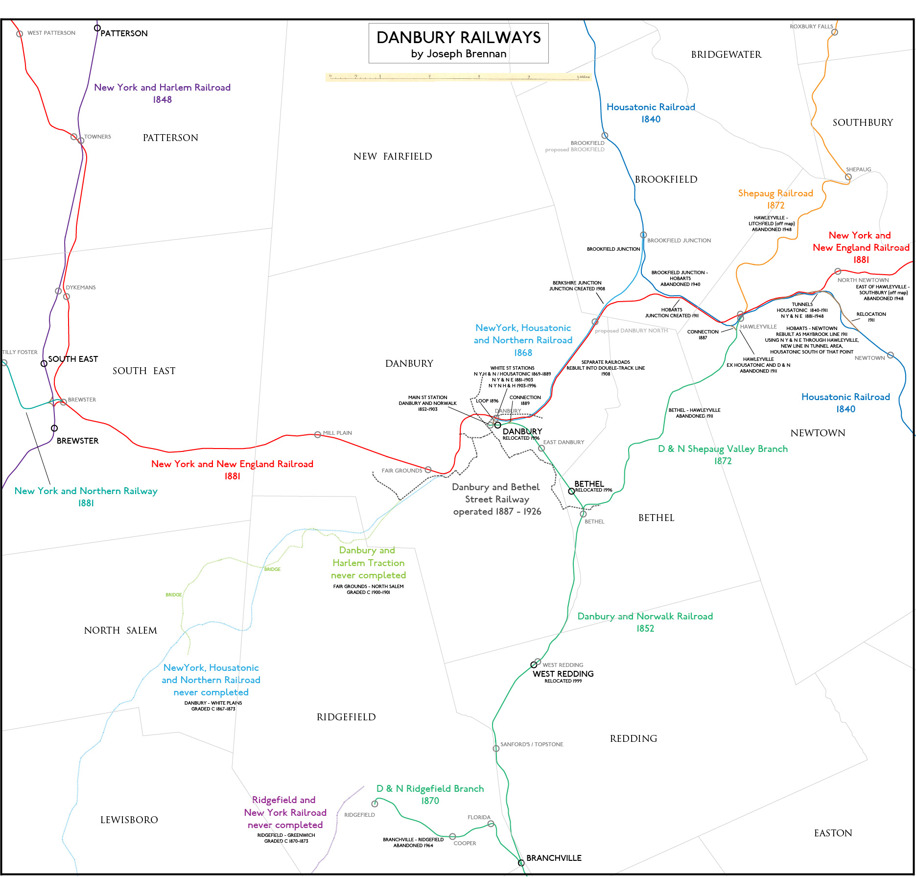
Danbury Railways revised


Last week we had an historical map of railways around Danbury, Connecticut, and I said, why not?

This week I say: Why not do it better?

Sometimes I can't let go of something when I know I didn't quite finish it. So I blew another 12 hours or so crossing the I's and dotting the T's.

First of all, the jpg map was awful. Here are much better ones, a big PDF with the topo map background and a smaller clean JPG without.


Besides an improved appearance, these maps also have various corrections and additions. Most notably, I added a strip on the west side where I had just barely cut off the interesting area around Brewster, and I added two more partially constructed railways.

Secondly, I rewrote the Historical Sketch section into better English style, and added more details. I can write good. Or write well. Whichever.

The result so far is semi permanently enshrined at http://www.columbia.edu/~brennan/danbury/.

I was especially surprised to learn that there were three partially constructed railways in the area. I had the New York, Housatonic and Northern last week, but now I've added the Ridgefield and New York and the Danbury and Harlem Traction line. These more than pipe dreams. All three companies purchased and graded many miles of property, leaving traces that can still be seen today.

As I mentioned last time, the NYH&N actually opened the small portion from Danbury to Brookfield Junction, which is still in operation today, and the company also graded another 23 miles (!) that was never operated, far into Westchester County. The Ridgefield and New York similarly graded all or most of its route down to East Port Chester (across the boundary river from Port Chester NY). The trolley line D&HT not only graded part of its route but actually laid about five miles of track and made a test run with a trolley borrowed from the Danbury and Bethel Street Railway.

Local railfans and history buffs have discussed the grades— here is a good one about the D&HT grade, although read carefully because it also references the R&NY grade and mentions the NYH&N.

I made two real finds at the U Conn MAGIC web site, the library's wonderful acronym for the Map and Geographical Information Center. They have a 1934 aerial photography set of the entire state that shows the Danbury and Harlem Traction grade very clearly. They also have almost all of the New Haven railroad valuation maps of 1915, providing enormous detail on the railroad's property and structures at that time, which was about its maximum extent.

The valuation maps, amazingly, include the entire Ridgefield and New York line from Danbury to East Port Chester, even though it was never completed. Notations show that the property from Ridgefield south was sold to the New Haven in 1906. The Ridgefield to Danbury section, which was added to the proposed road some time in the 1880s, is carefully detailed, but why is unclear, because the notes emphasize that the New Haven did not own the property.

Last time Charlie Warren commented that the New York, Westchester and Boston project included a proposed line to Danbury. I know that it was to have continued north from White Plains along a route very similar to that of the unbuilt New York, Housatonic and Northern. I haven't shown it since no work was done. However the New Haven's strange acquisition of the Ridgefield and New York property makes me wonder whether there was any idea of extending the NYW&B from its Port Chester terminal by that route to Danbury. It was already graded after all, although it would probably have needed extensive rebuilding to eliminate grade crossings and live up to the NYW&B standard.

I came across this amusing article about a property for sale in northwestern Greenwich, left over from the New York, Housatonic and Northern project. From the street you see a narrow lot (by local standards) 100 feet wide with a modest house on it, but... the property goes back almost half a mile! Type 56 locust road greenwich ct on Google maps.


.


Sunday, December 5, 2010

Riding the El - 4 - 155th St


I said back in Riding the El part 1 that I had been sent a packet of negatives in two sizes. The three parts documenting the Sixth Avenue El in 1938 and 1939 completed the '117' size film. The photographer— I assume it is the same photographer— then acquired a better camera that used '120' film, and he set off to document other Manhattan elevated railways that were scheduled to close in 1940.

The first subject he covered, very thoroughly, is the 155th St station of the Ninth Avenue El. The Sixth and Ninth Avenue Els had a joint line from 53rd St up Columbus Ave, 110th St, and Eighth Ave to the Harlem River. The Sixth Avenue El closed in December 1938 ; the Ninth Avenue El in June 1940. Sometime in that year and a half our photographer went up to 155th St.

He might not have realized that a stub el service, from 155th St to the Bronx, would continue to run past 1940. The 155th St station was not closed until 1958.


130-8. Looking north (east) from 155th St station toward Putnam Bridge.

Putnam Bridge was opened in 1881 for mainline railroad service. The New York and Northern Rail-road, later the Putnam Division of the New York Central Railroad, originally ran from 155th St elevated station to Brewster NY, using separate tracks added to the east side of the elevated structure. In 1918, elevated railroad service was extended over the bridge, and the Putnam Division began using a new terminal at Sedgwick Ave on the Bronx side of the bridge.

The tracks continuing straight, to the left edge of the image, go to a large storage yard.


130-8 detail. Putnam Bridge.

Although it's a little washed out in the sunlight, this is a great view of the bridge. In the right-hand distance is the Sedgwick Ave elevated station, beyond which the el runs into a short tunnel. The mainline terminal is obscured by the bridge. Notice that there was a public footpath on the bridge. This was a swing bridge that could rotate 90 degrees to allow tall ships to pass— a feature required on navigable waterways but not much used on the Harlem River.

The large building in the center is the H W Wilson Company, publishers of library reference books.


130-8 detail. Stairway.

By overexposing the image I was able to lighten up the shadows in the stairway on the right-hand side. They're all the same: Sunshine Krispy Crackers, 1st in Flavor.


131-1. Looking south at 155th St station.

The structure running left to right and over the el is the 155th St Viaduct, opened in 1893, connecting Macombs Dam Bridge to the heights west of Eighth Ave. Pedestrians on the viaduct could walk down to the elevated station.

The big ad under the platform was for Watkins's "Mulsified" Coconut Oil Shampoo, a much advertised product for many years.


131-1 detail. Uptown platform.

I like the pipe-railing construction holding the weatherbeaten enamelled metal sign for 155th St, and the evenly spaced reverse-threaded lightbulbs along the roof edge.


131-1 detail. Downtown platform.

I didn't notice at first that the advertising woman with a HEADACHE had the outline of a circular saw around her head. Yow!

The train on the right, pulled partly past the platform and with its end door open, is not in service. The open door and the white-shirted man down the platform make it seem like it was a warm day, but other photos show people with jackets.

One track in the distance seems to go up a grade worthy of a roller-coaster. More on that in a moment.


131-2. 155th St station looking north from the 155th St Viaduct.

We're looking down from the viaduct, and we can see the whole station and Putnam Bridge. On the left is the Polo Grounds, home of the New York Giants baseball and football teams at this time.


131-2 detail. Subway entrance.

You could almost miss the simple stairway down to the INDEPENDENT SYSTEM subway, for the station called 155th St / Eighth Ave. There must have been quite a crowd squeezing into that stairway after a game.

I can see a pitcher, left, and a squatting catcher, near the subway entrance, but otherwise I am not sure what the people in the empty lot are doing. Maybe they have arrived early for a game and they're waiting outside.


131-2 detail. Putnam Bridge.

On the far side of the bridge you can see New York Central Railroad cars at the Sedgwick Ave terminal. One reason the el was kept open north of 155th St was that it was the only transit connection for passengers arriving on the Putnam Division. Imagine, from June 1940 on, they would change to the el for one stop, change at 155th St with a stair climb and few steps outdoors to subway local trains, and change once more at 145th St or 125th St to subway express trains. It's amazing passenger service on the "old Put" hung on till 1958.


131-3. 155th St station looking east from the 155th St Viaduct.

What a crazy mess of stairways! The people at the upper right are on a side wing of the viaduct, which is otherwise just out of frame on the right. They could go down to the upper mezzanine of the elevated station, and from there they could go into the station or continue down to the street.

The elevated railway staff quarters has striped awnings and an amazingly tall exhaust pipe.

The bridge at the upper right corner is Macombs Dam Bridge, 1895, a road bridge that is still there. The empty lot at the bottom is the same one seen in 131-2.


131-3 detail. Eighth Avenue Coach bus.

I bet some of my readers want a good look at that bus. The Eighth Ave bus is still the number 10 (or M-10). It replaced the Eighth Ave streetcar line in 1936.


131-3 detail. Viaduct entrance to the 155th St station.

Three well-dressed people pass the time of day as if they were on solid ground. There's a traffic sign to the right, because cars could drive onto this little side extension of the viaduct.

All of these stairs and platforms are gone now. The viaduct is just a straight shot for motor traffic, and there are no access stairs at all between the viaduct and Eighth Ave.


132-3. Eighth Ave looking north to 155th St.

This shows the other side wing of the viaduct, on the south side. The tower controls the tracks on the south side of the station. The towerman doesn't look too busy.


132-3 detail. Eighth Ave at 154th St, looking north.

Street life circa 1940, and some old brand names.


131-4. Eighth Ave, looking south from the 155th St Viaduct.

This is the opposite of the previous view. That's the same control tower.

So there's that ramp. It lines up with the center one-way express track in the distance. The track that goes under connects the uptown local track with the additional fourth track in the foreground. They went to some expense (company money too) to make sure those two paths did not cross on the level. I don't get it.


131-4 detail. Eighth Ave, looking south from the 155th St Viaduct.

You could get a good look at the ramp from the 151st St local station. Just wait.

It's a little hard to see, but the center track ramps up again at the next station, 145th St, an express stop where the center track has its own upper-level platforms. A good view of that kind of station will be coming up in a future installment.


131-4 detail. Eighth Ave at 154th St, looking south.

Some street life, and a very nice example of a bishop's crook streetlamp. Everyone is wearing nice clothes. Maybe it was Sunday. Mr Cool with the light-colored suit is leaning on a newspaper rack near the little girl. I think he has some white on his shoes and his hat.

The downtown train has BURNSIDE AVE in its passenger-side front window, indicating that it is returning from a trip to the Bronx that ended on the center track of the Burnside Ave (Jerome Ave) station.


139-8. Eight Ave at 152nd St, looking north.

We're on the uptown platform of 151st St station looking back uptown. Trains ending their run at 155th St switched left and ran to the west side island platform, and the equipment then either ran back downtown or was taken into the yard. Trains continuing to the Bronx switched right, ran to the east side island platform at 155th St, and continued over Putnam Bridge.


139-8 detail.

Right behind the signal is a train to the Bronx. Above it is the 155th St viaduct.


139-8 detail.

More nicely dressed people enjoying a walk. This is from a different roll of film than the other pictures we're looking at, so I don't know whether it is the same day.


131-6. Looking south (west) from Putnam Bridge.

The Polo Grounds did not have a big sign anywhere that said POLO GROUNDS, which is just as well since polo was never played here. The big sign they had said N Y GIANTS.

There's a subway-style interlocking signal with two colored-light heads, and beyond is a semaphore signal. It was a little confused. Two oil lamps hang on a pole. Judging by the point of view there may have been a public footpath on both sides of the bridge.


Car 122 was still a gate car, a car with open platforms and gates at the ends. The trains in the station were among the many that had been modified with closed ends and automatic doors.

The control box is supported on Phoenix columns, a patented design for a cylinder made from four curved pieces of iron bolted together. Putnam Bridge was built by the Phoenix Iron company, so the box is probably an original 1881 structure that controlled the mainline terminal track at 155th St.


131-5. Looking west from Putnam Bridge.

The point of view is a little farther out on the bridge, maybe even over the water. At left is the uptown end of the Polo Grounds, and there's a glimpse of Coogan's Bluff, the cliff wall of Washington Heights.

The size of the elevated railway storage yard is matched by that of the two switch towers that control access to the dozens of storage tracks. Beyond the trains is a large shop building where trains were kept in repair. The multiple slanted roof sections were intended to bring daylight into the work areas. The slants all face south.

I don't know the purpose of the horizontal structure on the right that runs out to the edge of the water.


131-5 detail. Under the el.

There's always something funny going on in isolated areas under elevated railways. I wonder what's in some of those trunks, know what I mean? The man on the right with a white hat is doing some car repair right on the public street. The engine is under two hood flaps that open from each side. Does he know about the kids watching, behind him?

But wait a second... holy cow... what is the deal with that support column? It's indescribable. The columns in the street are Phoenix cylinders, and the ones at the far curb are boringly ordinary square-section beams, but this thing... uh. Let me get a grip. The lower part might be an early 1870s column from Greenwich St with a spreading top. But then what? Did they mount another one upside down on top of it? I think we were not meant to notice this. Maybe they had to do an emergency repair one day and this was all the good iron they had handy. I am speechless. I must stop here.

More next time.

Sunday, July 17, 2011

South Ferry III


In South Ferry I, we looked at the first elevated railway station at South Ferry, and in South Ferry II, we considered how New York Elevated managed to operate two lines out of the tiny two-track terminal. Now, we'll see when the better-known four-track terminal was built. This larger terminal lasted until 1950.

The Park Commissioners yesterday granted the privilege to the New-York Elevated Railroad Company to build a "Y" on the Battery, to connect with Pier No. 1, North River.

That's the Tribune reporting inaccurately on a significant event on July 3, 1878. This was the official permission to build a very short branch line not at Battery Place but at Whitehall Street. The Parks Department was not part of the city government, but a fairly independent body similar to the public authorities today. The Parks Department had jurisdiction over parks and also some public streets near parks. It appears from subsequent events that Whitehall Street, alongside Battery Park, was one of those streets.

The permission predates the opening of the Third Avenue El by a month and a half, but the company did not follow up immediately, forcing use of the inadequate old station.

The Third Avenue El was extended to 89th Street on December 9, and the papers described planned rush hour headways of two minutes from South Ferry. This could only have been done by turning some trains at the recently installed third track south of Franklin Square. A company spokesman said now that they would build a terminal at 129th Street and that "a similar station will be erected at South Ferry". Service to the end of the line at 129th Street began on December 30.


Bromley's Atlas of the Entire City of New York, dated 1879, above, shows the location of the buildings at South Ferry. The elevated terminal was sited along the west side of the ferry plaza. This may have been done to keep clear the space in front of the South Ferry ferry terminal, but I think even more likely it was done to make the elevated station as long as possible to accommodate Third Avenue trains of four or five cars. The station house is along the west side of the big ferry terminal, not in front of it, getting another car length or so for the station platforms.

Let's get a good look at the scene. The first three images below, from stereo views, are from unknown dates in the 1870s or even 1860s before the elevated railway was built.


A view from the water shows the South Ferry terminal. The map above and the name on the arch agree that the boat on the left is handling the Hamilton Ferry, and the empty slip on the right is for the South Ferry to Atlantic Avenue.


This view from over the Staten Island ferry building shows where the elevated terminal would be built, along the left side of the South Ferry building and along the edge of Battery Park.


Turning around, we see the front of the South Ferry terminal. Look closely and you can see the names South Ferry and Hamilton Ferry on each side. I wonder what colors this amazing building was painted! The elevated terminal would be built along the edge of the park and extending into the space to the right of the ferry terminal.


A detail of the cabinet card from South Ferry I looks down the edge of the park, where we can see the shacks serving as Staten Island ferry terminals.


Construction for the big terminal must have begun around December 3. That's when the political grandstanding about encroachment on the park started.

The Tribune described the work in an article of December 19:

The plaza near the South and Staten Island Ferries has now a very disorderly appearance, owing to the preparations of the Elevated Railroad Company to extend its tracks over a portion of it. Heaps of earth, stones and logs lie scattered about, while here and there laborers are engaged making excavations for the foundations of pillars. Pumping engines are required to keep several of the holes free from water, which flows in at high tide. In order to secure any foundation, the railroad company's engineers have been compelled to drive long wooden piles into the bottom of the holes. Besides excavating holes in the plaza, the railroad company is digging others in Battery Park. ... When all the tracks are completed the company will be able to dispatch trains with far more frequency than at present. A handsome new depot will also be constructed on the south side of the plaza.

Further progress was reported on January 31:

Work on the station and tracks at South Ferry is advancing, and it is thought that in a month trains will start from that point on a one-minute headway. ... The road is carrying an average of 90,000 passengers a day.

It took more than a month. A report of March 7:

The terminus in Whitehall-st is so far completed that ties are being put in place ; before it can be used and the old structure in Battery Park removed, the new station adjoining Staten Island Ferry will have to be built. With the arrangements completed at this point a train may start out on each side as one arrives.

That means "the old station in Battery Park removed". I'm surprised to read that they were up to laying ties on the new terminal trackways when they had not yet even started building the station house.

The opening of the City Hall branch (joining the main line at Chatham Square) on March 17 provided some relief. Rush hour headways became: South Ferry to Harlem 4 minutes, South Ferry to Grand Central 6 minutes, Franklin Square to Harlem 8 minutes, and City Hall to Harlem 4 minutes. Do the math: that's 47½ trains per hour in one direction on the main trunk between Chatham Square and 42nd Street.

Trains crossed at grade going in and out of the branches at Chatham Square and 42nd Street. New York Elevated's management didn't believe in interlocking systems and ran everything with flagmen. At 42nd Street, trains going uptown to Grand Central every 6 minutes crossed trains going downtown less than 1½ minutes apart. What could happen? A side-swipe collision there on March 25 put an end to this schedule after only eight days. Both branches were immediately closed, and on March 27 the company announced that platforms would be built at the junctions so that the branches would be worked only with shuttle trains.

On this occasion Company President Cyrus Field provided a clue to the opening date of the terminal at South Ferry:

Mr Field thought this determination necessary, as trains will be run from South Ferry in a day or two at one minute intervals, and then the danger at the cross tracks would be very great, as the trains at Chatham-square would not be more than a half-minute apart.

You would expect a news article would follow describing the wonderful new terminal at South Ferry, which may have opened on the weekend of March 29 and 30, or Monday March 31. But I have not been able to find one.

I do have an article in the Tribune for April 11 that mentions that the Third Avenue El was then operating 62 trains an hour in one direction in rush hours. This scarcely seems possible with a two-track terminal at South Ferry, but it is certainly impossible without it. Of the 62, some probably ran from Franklin Square. It's still astounding.

And let's look at the new terminal. The three images below are early, possibly close to opening day.


I think this first one is a great image. You can see the same Staten Island ferry shacks on the right, with a stairway direct from the elevated station. Toward the left, under the el, you can see the South Ferry terminal too. Compare it to the views up above.

This image might show Third Avenue cars and pre-1880 Ninth Avenue cars together. The car farther back is a 1878 Third Avenue car built by Gilbert and Bush, with pointed arches over the window— for transit geeks, it's the same type as Car G, which still exists, and might possibly even be Car G although that's impossible to determine. The closer car, far left, is at the Ninth Avenue line platform, and although the roof silhouette is consistent with the narrow pre-1880 cars, I don't think it's clear enough to say for sure. If it is though, then this image is no later than May 1880.


This stereo view seems to be from around the same time as the cabinet card. The ladder on the elevated station and the materials in the street make me wonder whether the elevated station has just opened, and some work restoring the street plaza is just being finished.


Around the other side, we can see the corner of the South Ferry building on the left.

This is a Third Avenue train, with the other type of 1878 Third Avenue cars, built by Wason, without the pointed arches. Both types had an oval on the side at the center of the car.

You can see steam from the engine that brought this train in, trapped at the end of track. When the train is pulled out by another engine, this one will follow it out to a point past the switches, where it will wait to move in to take another train out.


The site of the original station from 1877 became part of a track not used for passenger service but useful as the only connection between the east side and west side elevated lines. Two images from Charles Warren's pages show the connection.


This scene is looking west toward Battery Park, with the big South Ferry station to the left. An engine is ready to take out a Third Avenue train. The white pole toward the right is at about the location of the stairway up to the original station. The trees inside the triangle are in photographs of the old station.


This is a later view. The departing Third Avenue train is running across the site of the original station. As we saw in South Ferry I, the station stairs were on the sidewalk under the tower seen here, and the platform extended to the left of that point. There is only one connecting track, on the near side of the tower.

Third Avenue engines ran with the engine on the downtown side, while Ninth Avenue engines did the opposite— so an engine running through the connection to the other line was oriented correctly.

The old South Ferry terminal is still standing here, but there is something in front of it that may be an elevated walkway. The building on the right was built by the United States for the Barge Office and the Immigration service.


The Second Avenue and Sixth Avenue Els began running to South Ferry in 1880 and 1881 respectively. Paths for these additional trains were made by routing some East Side trains to City Hall and terminating some West Side trains at Rector Street.

The terminal was expanded by 1910 with longer platforms and side platforms. The Sixth Avenue El closed in 1938, and after the Ninth Avenue El closed in 1940, the west side of the South Ferry terminal was demolished. The Second Avenue El closed in 1942, and in 1950 Third Avenue El service from Chatham Square to South Ferry was eliminated. After that the remainder of the terminal was removed. Nothing of it can be seen today. Even the path of the West Side elevated in Battery Park has been obliterated by redesign, and Front Street, over which the East Side lines approached, has been closed and built over.

The Staten Island boats were shifted to the site of the former Brooklyn ferries early in the 20th century, and new terminals for them were completed in 1909, then 1956, and most recently 2005.


.