Last time I showed you a few old bridges in Hunterdon County. I looked around on the same website to see what we had closer to home.
The oldest bridge in Essex County is the Bridge Street Bridge spanning the Second River between Belleville and Newark. I went there.
The New Jersey Department of Transportation's Historic Bridge Survey, 1994, listed the bridge. This is part of the description:
CONSTRUCTION DATE: 1867
SOURCE: PLAQUE
MATERIAL: Stone
TYPE: STONE ARCH
DESIGN: BARREL
Physical Description: The single-span stone arch bridge is constructed of vermiculated coursed ashlar and finished with ringstones. Spanning 33' and measuring almost 30'-6" wide, the bridge carries a 2-lane road flanked by a concrete sidewalk and ashlar parapets with granite cap stones. A keystone on the east elevation is inscribed with the date, 1867, and the county freeholder minutes confirm the date of construction. The west parapet has missing stones at the north corner. No alterations to the span were noted. Plans were not located.
Historical and Technological Significance: The 1867 stone arch bridge is technologically significant because it is the earliest example of a stone arch bridge in the county, and it is well-preserved. Additionally, it is located in the extension division of Branch Brook Park. The park is listed in the National Register as a historic district, and the span is historically distinguished because it contributes to the historic character of the park.
Here is the west side parapet showing the missing stones at the north corner. In the background is part of Branch Brook Park, which is narrow here, and a few houses in Belleville.
The reddish stone should look familiar to New Yorkers. Local quarries were the source of the brownstone used to face many houses in Manhattan and Brooklyn.
Because of the park on the Belleville side of the stream, you can get around to see both sides of the bridge. Trees on the west side obscure the view, but the east side is clear.
I didn't notice any inscription on the keystone in real life, but an enlargement of the east side image confirms something is written on it.
The closeup also shows the vermiculated texture still present on most of the stones. It's not just an artifact of stone cutting, but was deliberately worked into the stones.
Although this is the county's oldest bridge, it is not now located on a main road. It's also not properly lined up with the streets on each side, as you can see below in an image I adapted from Google Maps satellite imagery. Modern maps don't show that the bridge is slightly west of where you'd expect it to be if it was intended to connect Summer Avenue (Newark) to Bridge Street (Belleville). The southwest wing parapet, shown in a thin blue line, seems especially out of position.
The bridge of course pre-dates the local street plan. But on the south side at least, it also seemed to me that old roads leading to the bridge were probably wiped out when the street grid was imposed.
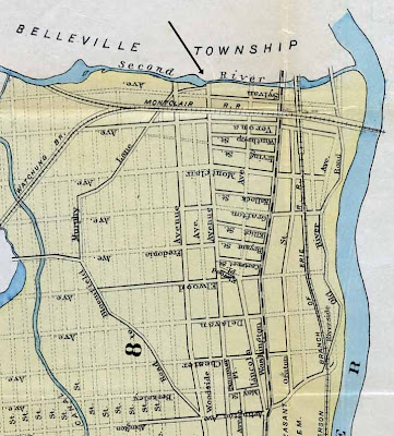
Below is a map of Newark dated 1872, when the bridge was only five years old, showing the old road pattern in the area. My arrow points to the bridge.
As early as this the next road east, Washington Avenue, was becoming the main road. The Newark and Belleville Horse Railroad was laid in it, and the newly opened Montclair Railroad had a North Newark station at the crossing. The Washington Avenue Bridge is the next-oldest in Essex County, built as one arch in 1868 and lengthened to three arches in 1869.
The unnamed road running southwest from the bridge explains the southwest parapet wing.
A second map from 1889 shows the proposed street grid in dotted lines. The doomed road to the southwest is named as Murphy Lane. The road called Woodside Avenue on the 1872 map is now Summer Avenue. The next two parallel streets west are a proposed street called (confusingly) Woodside Avenue, and an extension of Mount Prospect Avenue. The Newark, Bloomfield and Montclair Horse Railroad, which had wandered northwest, crossing Murphy Lane, was removed to Bloomfield Avenue in 1876.
Finally, here's an 1885 map that does not well distinguish proposed and opened streets, but does show the locations of old roads. Here we learn that Summer Avenue overlays a narrower old road called the Upper Road to Belleville (it is uphill from Washington Avenue). Near the bridge the Upper Road is even shown as lying in the western side of Summer Avenue— lining it up with the bridge!
"Montclair Depot" at Washington Avenue means the Montclair Railroad Depot.
Below, I've taken a "modern" map, the Newark Central Planning Board map of 1944, and overlaid two old roads, Murphy Lane and the Old Road to Bloomfield, using the 1885 map as reference. The circle near the top is the Bridge Street Bridge.
The other circle is the location of a curious holdover from the past, older than the Bridge Street Bridge. It's the last piece of the Old Road to Bloomfield. That's actually the name of the street as seen below.
The only address on it is 29 Old Road to Bloomfield, but it's an important one, the John Sydenham House, built in 1711. Photographs and plans made by the Historic American Buildings Survey in the 1930s are here. HABS called the condition poor, but the house was restored in the 1950s and it looks great today.
While I was in the area I was also going to grab a street sign image of an even stranger name, Viviparous Way, shown by the orange thing on the Bing Maps image below. It's just west of Bridge Street Bridge (my added circle).
Sad to say this street exists only on Bing Maps. It's not on any other map I could find on the web or in print, and it's not even found by Bing's search engine. It's also not there on the ground. Well, the street itself exists but it's just part of Manchester Place. I guess someone was having fun with the maps database. Someone, presumably, of a live-bearing species.
.


Viviparous Way is probably a copyright protection thing. If another map shows it, MS' cartography supplier and prove that the map was copied.
ReplyDeleteP
My Union County Hagstrom shows a non-existent cul-de-sac named Nilbog Way... fans of Troll 2 will immediately recognize it as the reverse of Goblin.
ReplyDeleteThere was a more boring "Avenue C" on the maps near a house where my family lived. Another very short dead end that did not exist. And no Avenues A or B in the vicinity! But what a boring name compared to Nilbog or Viviparous.
ReplyDelete