Sunday, August 28, 2011

Central Avenue Bridge


Scary bridge.
Central Avenue over City Subway
Status
Open to traffic
History
Built 1908
Design
Pony truss
Dimensions
Length of largest span: 112.9 ft.
Total length: 118.1 ft.
Deck width: 47.2 ft.
Inspection (as of 09/2008)
Deck condition rating: Fair (5 out of 9)
Superstructure condition rating: Poor (4 out of 9)
Substructure condition rating: Fair (5 out of 9)
Appraisal: Structurally deficient
Sufficiency rating: 49.4 (out of 100)

Structurally deficient.

I've gone under the Central Avenue Bridge a few dozen times on what is now called the Newark Light Rail line, and a couple of weeks ago I went over it.

Some interesting things about this bridge.

First, the angle of crossing is extremely skewed. Going along Central Avenue, you pass one steel truss on the left, then go through an intersection, and then pass the other truss on the right. See the aerial view from Bing below.


Second, the south side is really three trusses in a row, while the north side is just one.

Third, when built in 1908 it crossed over a canal, not a rail line. This is the only bridge over the city subway that was not built new when the subway was constructed.

I wanted to know how such a awkward bridge came to be built and why it's still there.


The Morris Canal was completed from Newark to Phillipsburg in 1831. Crossing New Jersey involves a lot of hill climbing, and the canal used 34 locks and 23 inclined planes. The planes carried the boats on cradles running on rails. The location at Central Avenue was close to the upper side of Lock 16 East (marked today by Lock St, near Warren St), and there was a widened basin in the area for boats waiting to lock through.

Central Avenue came later.

Below is a portion of a street map from 1853, which I annotated to show the future location of Central Avenue. If the drawing is accurate, no streets bridged the canal between New Street (at Lock Street) and Sussex Avenue.


This explains a lot. If Central Avenue had existed when the canal was built, they probably would have tried to avoid such a skewed crossing. Instead, Central Avenue was cut through later. Its width and almost straight path from Broad Street to the city line suggests some degree of dramatic gesture was involved, and therefore its unfortunate angle of crossing the canal simply had to be dealt with.

Central Avenue is not on a map from 1872, but does appear on a map from 1881. Therefore the structurally deficient bridge we have today replaced another one after roughly 30 years.

The first bridge was evidently strong enough to support a street railway. The Central Avenue cars began running in 1890.

Below is part of a plate from an 1892 real estate atlas. The south side of the implied bridge is shown as running from Jay Street to just east of Hudson Street, exactly like the existing bridge. The canal is not shown emerging on the north side of Central Avenue just west of Hudson, but the angles of the buildings imply that it did. The purpose of these maps was to show properties and buildings, so the depictions of other features like canals are not always precise. Most of the buildings shown are wooden, shown yellow, but a few are brick, shown pink.


The only slight detail I could find about the first bridge is in John Harrington Riley's very detailed chronology The Newark City Subway Lines (the author, 1987), where he writes:

On March 1, 1908 the Morris Canal Bridge on Central Avenue in Newark was closed as unsafe. While the new bridge was being built the Central cars were re-routed [...]. At 8:30 a.m. on Thursday, May 28, 1908 the Central cars reverted to their regular route via Central Avenue over the new canal bridge.

Below are parts of two plates from a 1908 real estate atlas that show the new bridge. (The atlas has a page break at Central Avenue, and the two don't quite line up, so I have just copied in the two parts.)

This atlas shows better than anything I've seen how the canal crossed under the street, and it provides a clue to how the bridge works.


On the southern side, there were two support columns shown by squares, with beams running across the canal to the masonry wall on the north side of the canal, under the road. This explains very well why there are three truss structures along the south side.

I made a diagram:


Span A rests on the north side truss (dark blue), the south masonry wall (brown), and a cross beam.

Span B has no truss, resting on the two masonry walls and two cross beams.

Spans C, D, E, rest on the north masonry wall, three trusses, and two cross beams. The cross beams originally extended beyond the trusses to reach masonry columns on the south side of the canal. During construction of the subway, new columns were placed directly under the ends of the trusses and the outer part of the beams cut out.

Here is what it looked like.


The Morris Canal was closed in 1924. The photograph above shows the view from Norfolk Street after it was drained. The occasion might be the date in 1929 when the City of Newark contracted to build a trolley rapid transit line in the canal bed.

You can see the three trusses along the south side of Central Avenue, and one of the cross beams, the other hidden behind it from this angle. You can also see that depositing junk into abandoned property is not a new thing in Newark.

The subway opened in 1935. Originally subway services resembled the trolley subways now running in Boston, Philadelphia, and San Francisco: cars ran out of the subway into street railways. The Central Avenue car line was one of those routed into the subway. Ramps were built that can be seen in the 1955 photo below, taken from under Norfolk Street bridge.


Photo by Frank Pfuhler, as seen on David Pirmann's nycsubway.org site. Inbound Central Avenue cars left the street at Hudson Street and came down ramp seen on the left. Outbound cars went up the ramp on the right and crossed over the subway on a new bridge that rose alongside the Central Avenue Bridge. Central Avenue cars stopped running in December 1947, but as you can see the ramps were still there eight years later (and many years more).

In August 2011 I took the view below from Norfolk Street bridge, from an angle similar to the 1920s photograph. The remains of the ramps are still there, but the track bridge was removed a long time ago now.


I'm sorry there is a chain-link fence everywhere you turn here. This is just about the best view you can get now from street level.

On a much earlier occasion, Sidney Selleck Jr snapped the view from the other direction, looking down the ramps. (Dot screen courtesy of its publication in Traction Extra number 1, The City Subway / Newark's Best Kept Secret, by Joseph Saitta (Merrick NY: Traction Slides International, 1985).)


Those are new cross beams, not the old ones, holding up the track bridge, and I think they were not connected to the Central Avenue Bridge. The date here seems to be in the 1935-1947 era when the ramps were in use.

Below, my very sorry attempt to get a similar point of view in August 2011. Note the very end of the pipe railing that once continued onto the track bridge.


Check the fine rust detailing on the rest of the steel. Note: this is not one of those modern buildings where the rust is intentional and makes it stronger. No.

I have worse photographs. Let me try your patience a little longer.


This happens to show two details well. First, see the support column under the ends of the trusses. On top of it is a support pole for trolley wire that really could have been removed. If you look near the left, another pole marks the location of the other support column. Second, under the bridge you can see a little of the masonry side wall. The white on the stone is some mixture of graffiti and pigeon droppings.

The photo below looks across Central Avenue from the north side. The crack in the sidewalk running out into the street shows the angle of the north side of the masonry wall as it crosses the north side of Central Avenue. The wall curves left as it goes.


I could not get a good photo of the north side truss. It's covered in chain-link fence, and the possible view from the next bridge, corner of Duryea and Dickerson, is totally obscured by a dense growth of ivy on another chain-link fence. But you can guess what it looks like. Rust.


Should this bridge be preserved? No. Let's replace it. If the City of Newark can't afford to replace it, let's at least remove it, while we can choose how to do it, not after it has fallen onto the tracks. We might be able to live without it. I don't know the politics involved, but that's midday weekday traffic you see there in the photo. The bridge is scary.


.


Sunday, August 21, 2011

Bridge Street Bridge


Last time I showed you a few old bridges in Hunterdon County. I looked around on the same website to see what we had closer to home.

The oldest bridge in Essex County is the Bridge Street Bridge spanning the Second River between Belleville and Newark. I went there.

The New Jersey Department of Transportation's Historic Bridge Survey, 1994, listed the bridge. This is part of the description:

CONSTRUCTION DATE: 1867
SOURCE: PLAQUE
MATERIAL: Stone
TYPE: STONE ARCH
DESIGN: BARREL

Physical Description: The single-span stone arch bridge is constructed of vermiculated coursed ashlar and finished with ringstones. Spanning 33' and measuring almost 30'-6" wide, the bridge carries a 2-lane road flanked by a concrete sidewalk and ashlar parapets with granite cap stones. A keystone on the east elevation is inscribed with the date, 1867, and the county freeholder minutes confirm the date of construction. The west parapet has missing stones at the north corner. No alterations to the span were noted. Plans were not located.

Historical and Technological Significance: The 1867 stone arch bridge is technologically significant because it is the earliest example of a stone arch bridge in the county, and it is well-preserved. Additionally, it is located in the extension division of Branch Brook Park. The park is listed in the National Register as a historic district, and the span is historically distinguished because it contributes to the historic character of the park.

Here is the west side parapet showing the missing stones at the north corner. In the background is part of Branch Brook Park, which is narrow here, and a few houses in Belleville.


The reddish stone should look familiar to New Yorkers. Local quarries were the source of the brownstone used to face many houses in Manhattan and Brooklyn.

Because of the park on the Belleville side of the stream, you can get around to see both sides of the bridge. Trees on the west side obscure the view, but the east side is clear.


I didn't notice any inscription on the keystone in real life, but an enlargement of  the east side image confirms something is written on it.


The closeup also shows the vermiculated texture still present on most of the stones. It's not just an artifact of stone cutting, but was deliberately worked into the stones.

Although this is the county's oldest bridge, it is not now located on a main road. It's also not properly lined up with the streets on each side, as you can see below in an image I adapted from Google Maps satellite imagery. Modern maps don't show that the bridge is slightly west  of where you'd expect it to be if it was intended to connect Summer Avenue (Newark) to Bridge Street (Belleville). The southwest wing parapet, shown in a thin blue line, seems especially out of position.


The bridge of course pre-dates the local street plan. But on the south side at least, it also seemed to me that old roads leading to the bridge were probably wiped out when the street grid was imposed.

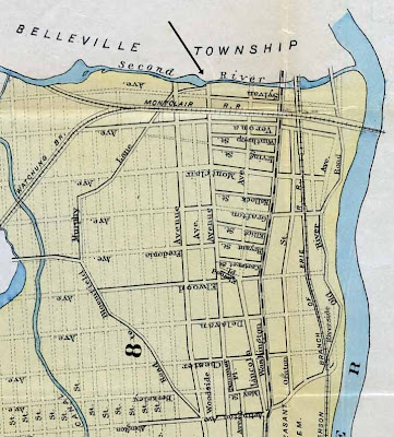
Below is a map of Newark dated 1872, when the bridge was only five years old, showing the old road pattern in the area. My arrow points to the bridge.

As early as this the next road east, Washington Avenue, was becoming the main road. The Newark and Belleville Horse Railroad was laid in it, and the newly opened Montclair Railroad had a North Newark station at the crossing. The Washington Avenue Bridge is the next-oldest in Essex County, built as one arch in 1868 and lengthened to three arches in 1869.


The unnamed road running southwest from the bridge explains the southwest parapet wing.

A second map from 1889 shows the proposed street grid in dotted lines. The doomed road to the southwest is named as Murphy Lane. The road called Woodside Avenue on the 1872 map is now Summer Avenue. The next two parallel streets west are a proposed street called (confusingly) Woodside Avenue, and an extension of Mount Prospect Avenue. The Newark, Bloomfield and Montclair Horse Railroad, which had wandered northwest, crossing Murphy Lane, was removed to Bloomfield Avenue in 1876.


Finally, here's an 1885 map that does not well distinguish proposed and opened streets, but does show the locations of old roads. Here we learn that Summer Avenue overlays a narrower old road called the Upper Road to Belleville (it is uphill from Washington Avenue). Near the bridge the Upper Road is even shown as lying in the western side of Summer Avenue— lining it up with the bridge!


"Montclair Depot" at Washington Avenue means the Montclair Railroad Depot.

Below, I've taken a "modern" map, the Newark Central Planning Board map of 1944, and overlaid two old roads, Murphy Lane and the Old Road to Bloomfield, using the 1885 map as reference. The circle near the top is the Bridge Street Bridge.


The other circle is the location of a curious holdover from the past, older than the Bridge Street Bridge. It's the last piece of the Old Road to Bloomfield. That's actually the name of the street as seen below.


The only address on it is 29 Old Road to Bloomfield, but it's an important one, the John Sydenham House, built in 1711. Photographs and plans made by the Historic American Buildings Survey in the 1930s are here. HABS called the condition poor, but the house was restored in the 1950s and it looks great today.


While I was in the area I was also going to grab a street sign image of an even stranger name, Viviparous Way, shown by the orange thing on the Bing Maps image below. It's just west of Bridge Street Bridge (my added circle).


Sad to say this street exists only on Bing Maps. It's not on any other map I could find on the web or in print, and it's not even found by Bing's search engine. It's also not there on the ground. Well, the street itself exists but it's just part of Manchester Place. I guess someone was having fun with the maps database. Someone, presumably, of a live-bearing species.


.

Sunday, August 14, 2011

Bridges of Hunterdon County


There was a book with a title like this. The resemblance ends there.

Looking for an excuse to go to countryside of West Jersey, I thought we could go check whether the Green Sergeant covered bridge is still standing, and then have a lunch and brew at the Ship Inn in Milford, on the Delaware. The best bitter, a batch they made the day we went, proved to be outstanding. But let's talk about bridges.


Hunterdon County turns out to be a mecca for old bridges. You could drive around for days looking at nineteenth century bridges. I decided to start with some of the oldest ones. They're usually one lane wide, and if they haven't been replaced in the name of progress it means they're on minor back roads in the woods and fields. Those are the roads I like.

The oldest bridge reported is a small pony truss bridge dated 1834, rehabilitated 2002, but I couldn't see anything old left. See here.

The next oldest is a stone arch bridge from 1837, rehabilitated 1974. What they did was widen the bridge to accommodate a modern two-lane road. The west side has the 1837 date stone, but otherwise it's all new. The original east side is mostly intact as you can see here:


Driving off along the Dunkard Church Road, we found by chance a very nice bridge that was not listed in my online sources. It's on the Sandbrook - Headquarters Road. It looked to me pretty similar to the bridge from 1837, but its date stone showed a much later date, 1873. I was surprised to find online a news report about major repairs done to the bridge in 2009 after the arch had begun to collapse. You can see that here on the Delaware Township Post's web page. The county road department found out that historically accurate repair came in for less than half the cost of replacing the bridge with a new one.


The road department in fact got so excited about it that they set out to do something similar for another stone arch bridge, without obtaining the proper permissions— which happened to be the next one we visited, although I had no idea about the reconstruction until days afterwards.

The Pine Hill Road bridge was built in 1849. In this case the planned repairs would not have been historically accurate, but fortunately work was halted while the proper permissions were obtained.

The bridge doesn't look like much from road level as you can see below.


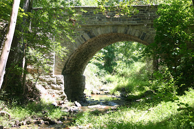
This is right around the corner from the Green Sergeant covered bridge, which is obviously more interesting to look at seen from road level. But the opposite is true when you go down to the riverbed. The public are invited into the Wickecheoke Creek Preserve, so feel free. We did.

You didn't expect this, did you?


That is a beautiful bridge.

With advice from local historical experts, the arch was repointed and made strong, and the parapet along the road was rebuilt in the early months of 2010 using local stone. It looks good, and the bridge now will last many years more.

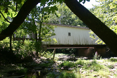
We made our way down the stream bed a very short distance to the Green Sergeant bridge.


This is the last nineteeth-century covered bridge in New Jersey. It's very picturesque.

There are tens of thousands of Green Sergeant bridge photos on the web, so I was reluctant to add to the deluge. I like to write about uncommon things. I like the stream-level views above, which are less common but far from unique. But one thing I've never seen is a view from directly under the bridge.

This is where the magic dies, and why I think the Pine Hill Road bridge is better from the perspective of the stream bed. Take a look.


This is a steel beam deck bridge, spanning the space between concrete abutments built in 1961, the year cast into the concrete. The other bridge to the right looks about the same from below.

Here is the straight dope. The Green Sergeant bridge was built in 1872 to replace an older (non covered) bridge, using the same stone abutments. Records show that the older bridge was repaired in 1787, but I haven't been able to determine when it was first built. It might have been the 1740s, when a mill was built nearby.

In 1960 the bridge was damaged, and the county road department set out in their routine way to replace it with a modern bridge. After considerable public outcry about the historical significance of the last covered bridge in New Jersey, a plan was made to build two one-lane bridges, and reassemble most parts of the covered bridge onto one of them. And that's what we have today, two bridges opened in 1961.

The stone abutments, by far the oldest component, were destroyed at that time. As I understand it, the wooden queenpost through truss which is still visible inside the bridge no longer supports anything but itself. The steel girders that are enough to hold up the other bridge are presumably enough for the covered bridge too. So it's a bit of a fake, although the wooden beams are original.


I like the bridge anyway, and I hope you do too.

The namesake is Richard Green Sergeant, a farmer who operated the Sergeant Mill nearby. He was known as Green Sergeant, and his surname is pronounced surge - ent, not sarge - ent. The locals like to catch visitors on this. I wish I could tell you how the locals pronounce Wickecheoke Creek but I don't know. Wickey - chokey? They probably just call it the creek.


I had a Cornish pasty for lunch. Now I can say I've had one, been there, done that, and I can order something else next time with a clear conscience. But that Imperial pint of best bitter!


.

Sunday, August 7, 2011

Genius and Stupidity


Email received:

From: webmail@mnsi.net <webmail@mnsi.net>
Date: Wed, 3 Aug 2011 19:59:15 -0400
Subject: ATT: example.edu Account User

ATT: example.edu Account User,

Our data base has full and we want to expand to a better service, also we want to change our log in page for all example.edu User to prevent to receiving of unwanted emails. We requested that all our customers should send us the bellow details:

User Name_______
Pass Word________
Date of Birth___

Failure to send us the above information 48hrs after receiving this email will render your account useless.

Thanks,
example.edu Account Dept.

Shout the "pass word" loudly— they want the bellow details.

I don't like to mix work and blog, but I'm going somewhere with this. There are several attempts a day to send messages like this to our user community at example.edu, and we block almost all of them using custom rules that I created. This past week two of them made it through and I was not feeling too good about it.

The one above was very old fashioned. It wanted the person to send the credentials by reply email. We can block the replies. They took the trouble to insert our edu domain into the text many times, which they don't usually do. That makes it spear phishing, not just phishing.

Next one. I've changed the sender. This was sent from a user account that was probably stolen using a message like this. I could mock the sender by leaving the name. I won't. I've changed the web page it directs to, also.

From: First Last <flast@bpcc.edu>
Date: Fri, 5 Aug 2011 08:51:25 -0500
Subject: Important Notice fron the Helpdesk

EMAIL ACCOUNT UPGRADE

Your E-mail box has reached its maximum limit of 20 GB of storage and Your account will be disabled if you do not update now.

example.edu   To upgrade your account,please click the link below and follow the instructions to upgrade to more storage space.

http://exemplo.com.br/forms/use/webmail/form1.html

Your account will remain active after you have confirmed your account successfully.

example.edu   |Auburn,Alabama 36849

=A9 Copyright 2011 Regulation

This is the modern way. They send you to a web page to give away your identity.

Mail fron our helpdesk does not usually come from another edu domain, nor have we relocated the university to Auburn, Alabama, so this was not totally convincing.

I often check the web page used in these things. This one was a commonly used form made with the phpFormGenerator software. When you have a URL, if you go up the tree by deleting one level at a time off the right side, sometimes you get to other pages that will tell you whose site it is. With these phishing pages, chances are the thieves don't own the web site. More likely they stole a password to get access. It's what they do.

In this case, once I backed up to http://exemplo.com.br/forms, I got to a page that showed me the forms I had created so far, and asked whether I'd like to create another one. And for each one I had created so far, it asked whether I wanted to delete it. So in this case the thieves did not steal a password. You don't need one. D'oh! I told the site owner and the hosting service.

The form was gone the next day.


But let's get on to the good part. Look at the box on the left side under the title "wise words".


What is the difference between genius and stupidity?
Genius has limits.
— Albert Einstein.

Oh, that Einstein. I wondered on what occasion he said this.

Almost at once I also thought of Yogi Berra's wise words, "I really didn't say everything I said". That is the title of a book he wrote, so I think he did say that one.

Famous quotes are always by famous people who are known for famous quotes. Mark Twain, Albert Einstein, Thomas Edison. They said a lot of things they didn't really say.

Google says there are 1,710,000 web pages containing that quote and the name Einstein. Could they all be wrong?


Well of course they could all be wrong.

There's an alternate quote:

Only two things are infinite, the universe and human stupidity, and I'm not sure about the former.
— Albert Einstein

The mention of the universe makes it sound a little more like Einstein. He was always thinking deep thoughts about the universe and infinity.


I tried various searches to get past the nearly two million people quoting other people quoting other people in endless recursion.

The saying with "the difference between genius and stupidity" is common in print only since 1996. It must have appeared in some widely read or heard source that year. And it was not at first attributed to Einstein. It seems to be anonymous until 2000.

The oldest print citation I could find is from 1961. It's in a trade periodical called Grassroots Editor, volume 2 page 34. The page contains humorous quotes collected from local papers.


One man says that the difference between genius and stupidity is that genius has its limits.
Louisville (Ky) Irish-American

Einstein died in 1955. I'd like to have found the quote somewhere during his lifetime, if I'm going to consider that he might have said it. Did the editor of the Louisville Irish-American make it up? I wouldn't rule it out.

I've got to say that a date as old as 1961 surprised me. The sarcastic tone sounds either more modern or else jumps us back a century to the days of Mark Twain.

But the gist of the quote might have been stated earlier in a different form. So I looked a little further.

Back! Back!


In the scientific biography Claude Bernard by Michael Foster, 1899, page 229, we find:

But in the origin of the hypothesis out of the observation, and in the framing of the needed experiment, there is room for all the difference between genius and stupidity.

He goes on to imply that there are more ways to be stupid than genius, but he doesn't make it into a pithy remark. He keeps to a certain elevated tone that you can probably pick up from the one sentence.

Back in 1873, if we had picked up an issue of Every Saturday / A Journal of Choice Reading, we would find on page 530 an article called "The Modesty of Genius" by an author whose name is not supplied. He or she writes as follows (in an essay that runs for twenty-two pages of double columns in small print, to be continued next issue, that makes me wonder how far into the year it took to reach page 530):

The man of genius attributes to obstinacy or idleness what is the result of good, plain, honest stupidity. [...] Perhaps it would be as well if, for a brief period of his life, everybody was condemned to be a schoolmaster or a crammer, in order that he might more or less fathom the stupendous abysses of human stupidity.

There! The stupendous abysses of human stupidity! It's not the quickly tossed-off remark that Einstein made in another universe, but it speaks of the genius's limitations in comprehending stupidity itself. If only there had been a witty bon mot the author could have put in there.

Let's go forty years earlier if we may. In a number of The European Magazine and London Review from 1821, page 301, we come to an article by M M D called "On the Gradations of the Human Intellect". In one of the shorter sentences he or she has this to say:

The most sublime genius has but indistinct views, or confused ideas, of whatever is placed beyond the proper limits of his understanding ; and though he has clear ideas of whatever is placed within these limits, this does not distinguish him from the dunce ; for the stupidest mortal will perceive whatever is placed within the reach of his understanding, as clearly and distinctly as Locke or Newton.

That's 190 years ago. Have we reached the limit? Maybe not. According to some web pages, we can go all the way back to the poet John Dryden (1631-1700), who wrote:

Only two things are infinite, the universe and human stupidity, and I'm not sure about the former.
— "Cymon and Iphigenia" (l. 107)

This was exciting! It's the alternate version contrasting stupidity not to genius but to the universe, and it's got a specific cite down to the line number in a certain poem. It sounds so modern, and yet, they couldn't put it on the web if it wasn't true.

Sigh. The World Wide Web lets us down again. It lets us down, it lets us down. Here is what you will find at line 107 of "Cymon and Iphigenia":

The fool of nature stood with stupid eyes
And gaping mouth, that testified surprise.

It's somewhat apt, but not what we were looking for.


Inevitably, while I was searching around, I came across this, and said to myself, self, you didn't know it, but this is the quote you were looking for:

There is such a fine line between genius and stupidity.
- David St Hubbins, This Is Spinal Tap

But, despite the solemn word of 6,410 web pages, that's not what St Hubbins said. I don't know what to believe any more. My faith in humanity is shattered.

This is actually how it went:

David St Hubbins: It's such a fine line between stupid, and uh...
Nigel Tufnel: Clever.
David St Hubbins: Yeah, and clever.

And with this week's blog: Q E D.


.