Not long ago I wrote a little about the first elevated railroad in New York, the Greenwich St and Ninth Ave line. The first segment, Dey St to 29th St, was originally operated by cable in 1870, but when that proved hopelessly unreliable, a new company began operating in 1871 with one a train pulled by a very small steam engine.
If we jump ahead just two years, we find the New York Elevated Railroad operating a profitable small transit line. As of February 1873 there were intermediate stations at Franklin St, Watts St for Canal St, Little West 12th St, and 21st St. Four engines were available to pull eight passenger cars. A second track had been added, running for three blocks near the midpoint of the line, from Perry St to Bethune St.
The second track was a breakthrough. Now trains could leave each terminal every half hour and pass at that point. The passing siding, complete probably in October 1872, led to many more improvements. The one we're going to look at now is the downtown terminal at Number 7 Broadway, which was used for four years, January 3, 1873 to April 4, 1877.
The location is amazing in today's terms. It was an old house and a former railroad freight yard on property facing Bowling Green and running through to Greenwich St. Today this is some of the most valuable land in the city, but in 1872 it had declined over the years into a neighborhood of warehouses and hotels supporting the docks along the river. A railroad terminal and maintenance shop was not out of place.
Here is the location.

The base map above is from 1880, so it shows some later elevated construction. The elevated track that existed in 1873-1875 is shown by red lines. It runs over the east curb of Greenwich St and into the property we're discussing. The house at number 7 Broadway is shown in brown.
The New York Daily Tribune for November 23, 1872, gives the best description of it that I have found:
At Nos 5 and 7 Broadway, near Battery-place, a depot is rapidly building. This will be of iron, and will be completed by December 1. The first floor will be about four feet above the sidewalk and five feet below the level of the track, and will be devoted entirely to waiting-rooms for passengers ; indeed the entire building is to be used for this purpose at present, though the company's offices will by-and-by occupy a part of it. From the waiting-room stairs ascend to the railroad.
The tracks will extend to the lower side of the building, and at this point will be nine feet above the sidewalk. The space between will be used as a storehouse. The curve necessary to bring the road, which now ends in Greenwich-st, into Broadway, will be at a point just below Morris-st. From Greenwich-st to the depot there will be four tracks side by side, in order to accommodate the travel which is now rapidly increasing, especially large numbers taking the train connecting with the 5 p m Hudson River Railroad train. By this arrangement four trains can be started at the advertised time, and the others taking passengers who have reached the depot earlier.
This is not completely right in detail, but it's pretty good.
The article also mentions the third and fourth engines on order, and the planned service of trains every 30 minutes, but the reporter does not mention the second track that would make that frequency possible. In the last sentence he assumes an expansion of one-way service on single track, all four trains running uptown together. I don't think they were really operated that way, although possibly they were in rush hours.
A remarkable stereo view provides the only known image of the station from the Bowling Green side. I've enlarged the available digital image here, so pardon the pixellation.

The New York Elevated Railroad owned the lot with the trains, 5 Broadway, and the old house beyond it, 7 Broadway. There's a ghost of a house on the side of 7 Broadway, but it was gone for at least 20 years at the time of this photograph. To the left of the trains is 1 Broadway.
The ground floor under the trains looks like it might be concession stands. There seems to be a stairway to the trains on the far side, but there also seems to be an open door into 7 Broadway at track level, converted from a window. Three trains are in the station.
Below is an image from the early 1890s, with some house numbers. This gives a better idea of the setting on Bowling Green.

The former station at 3 and 5 Broadway has stores at ground level and a second floor. Number 7 looks relatively unchanged and was probably rented as offices. A one-story building at number 9 houses "Our Club" and another at number 11 has a "Ticket Office" for a railroad or ship line. The signs on the side of number 13 are for Die Deutsche Gesellschaft der Stadt New York and Braguglia and Coreno's Cafe and Restaurant. The motley collection of buildings beyond made up the Stevens Hotel. Numbers 3 to 11 would be removed in 1895 for construction of the Bowling Green Building.
If we go around to the Greenwich St side, we can see the tracks. This is from a stereo view photographed in the autumn of 1876.

I drew the tracks on the map based on this view. It's too bad engine Yonkers blocks the part of the view, because it looks like there is a three-way switch there. Railroads avoid those, but space was tight here. Notice that there are five tracks, not four described in the Tribune article. The trees in the background are in Bowling Green.
From the left, the back of number 7 Broadway, and in the foreground, the brick wall of the former railroad freight yard has been cut back crudely to allow the elevated tracks in. Left middle is an interesting collection of items including the outer shell of a steam dummy and a handcar. Top middle, the back of number 1 Broadway, and to its right the Washington Hotel, which faced Battery Place. Lower right, Yonkers is coupled to a few cars on the old track down to Battery Place, used at this time as another siding.
Something else to notice is that there is essentially no space between the trains. This agrees with the scale on the map, which shows the station to occupy only about 40 linear feet along Broadway, or roughly 8 feet wide per track. How did passengers get into the trains?
Keep in mind that the second track I mentioned was the only second track on the railroad. How did the trains reverse at the end of the line? In the days of steam, railroad terminals routinely had an escape track to let the engine run around the train. Even if the engine did not actually turn around, it would move to the front of its train.
The answer is that New York Elevated used what is now called push-pull operation. Every photograph and drawing I have seen before 1877 shows the engine at the uptown end of the train. I am convinced that the engine stayed there at all times, and that when running downtown it pushed the train ahead of it. The engineer and fireman stayed with the engine, and relied on the rear brakeman to convey information about what lay ahead.
Newspaper reports of an accident in December 1876 make this quite clear. At the start of a two-track section at Vandam St, an uptown train was erroneously switched across the street to the downtown track, where its engine collided with the lead car of a downtown train that was waiting to enter the single track section.
The switchman gave the signal indicating everything was right, but through forgetfulness on his part he had left the switch open. The engineer of the up train when within a few yards of the switch saw that it was misplaced, and immediately applied the air-brake and gave the signal to the brake-men to apply the hand-brakes.
The cab of the engine was almost completely demolished, and the platform of the car on the down town train was destroyed. The passengers on both trains were thrown from their seats by the shock of the collision, and some three or four were slightly injured on the hands and legs.
The significance of this to 7 Broadway? Every train came in with the engine trailing. Every train had passenger cars at the end of track. In the photograph from the Broadway side, you see three trains with cars at the end of track. In the photograph from the Greenwich St side, you see four trains with engines visible, and one that I think has its engine detached.
So my conclusion is that at 7 Broadway they only needed access to the last platform of the last car, and people walked through the train to and from that point. Platforms between the tracks were not needed.
But this meant that the company could not convert to engine-first operation as long as they used the 7 Broadway terminal. The terminal was closed when the extension to South Ferry was opened. Some of the earliest depictions of trains at South Ferry in 1877 show engines running at the downtown end of trains for the first time. So as soon as it became possible, the company converted to a safer mode of operation where the engineer himself could always see the track ahead.

This shows how you can get an engine to the head of a train at a terminal, as long as there are at least two tracks outside the terminal. Start with engine 1 waiting on one track. Engine 2 pulls a train in. Engine 1 follows it in and couples to the other end, as engine 2 uncouples. Engine 1 takes the train out, and engine 2 follows it out and waits. Repeat.
At South Ferry, the extra tracks were available immediately outside the station. At the north end, which was 59th St station by 1877, the line was single track for the last eight blocks from 51st St, but still the same escape could be operated. The time it took to turn at 59th St was then the limiting factor on train frequency. This method of escaping engines to the front of every train became possible only when the second track opened to 51st St, about November 1876, and more importantly when the 7 Broadway terminal was closed in April 1877.
__________
Bonus feature.
The map up there at the top also shows the complete length of the first section of the el built in 1867, from Battery Place to a point just north of Morris St. The famous photograph below shows Charles T Harvey in front of 37 and 39 Greenwich St.
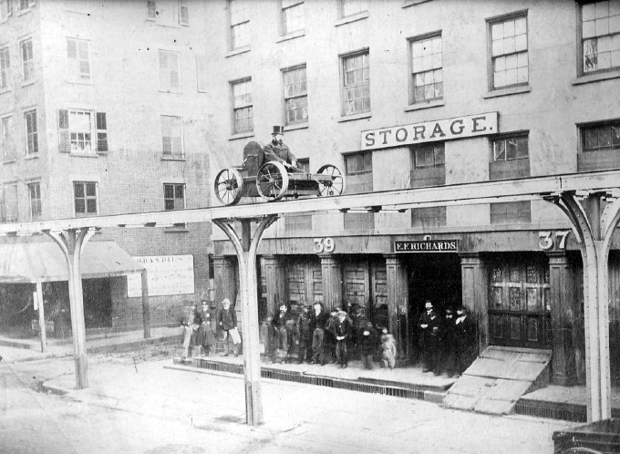
At that date, Trinity Place was a narrow lane that ran from Liberty St to a dead end behind the buildings on the north side of Morris St. Its southernmost outlet was Edgar St, a bit north of the dead end. That's the reason Edgar St existed. In 1869 the city bought out properties in order to continue Church St south. A totally new street was created through three blocks from Fulton St to Liberty St, and from there Trinity Place was widened and opened through to Morris St and Greenwich St. The new street was completed late in 1870. The photo of Harvey shows on the left a building on the north side of Morris St that was removed in the Church St project.
I've noticed also that the house numbers on Greenwich St shifted sometime in the 1880s. The old number 23 became 13 (but the next building remained number 25), and numbers 11 down to 1 were spread over the remaining lots, so that a few properties running through the block now had the same house number on Broadway and Greenwich St. The building with the "13 STORAGE" sign seen in two images in Greenwich St El Cars was the original 13 Greenwich St shown on the map here.
The base map (first image) is from the David Rumsey Map Collection, a terrific site for map fans. The image of the station from the Bowling Green side (second image) was rescued from Ebay by Charles Warren and can be seen on his Ninth Ave El page. The others are from my collection.
.
We need to determine when the four Track South Ferry terminal was built. See my latest early photo of the South Ferry Terminal.
ReplyDelete