Be it known to all whom it may concern: that at the request of Jonathan Crane and Nathaniel Wheeler, of Newark, Gentlemen: I have surveyed for them a tract of land lying between the Rahway River and Crooked Brook, within the bounds of Newark aforesaid...South and west by said Crooked Brook; north, Ebenezer Tompkins; east, by said river...
— Document dated March 10, 1713/1714, quoted in Shaw's History of Essex and Hudson Counties.
I referred to this document in Stone House II. Wait! No! I'm not going on and on about stone houses again. This time we're going to explore the Crooked Brook.
Our journey is not an easy one, because parts of the Crooked Brook are underground now. And because it really is a crooked brook, the parts that you can see run in different directions, as if they had nothing to do with each other. Until I wrote Stone House I didn't realize myself that they were all the same brook.
It's funny that some residential property developers treated the Crooked Brook as a picturesque feature that would increase value, while others hid it in a large pipe and tried to pretend it wasn't there. But that's what happened.
We will begin the expedition at the mouth of the Crooked Brook and work our way upstream to the mountain. You can come too.
I bet you're thinking of the great explorers seeking the source of the Nile. Except for certain details, like this brook isn't famous and the distance can be walked in about an hour, it's pretty much like that.
The Crooked Brook debouches into the East Branch of the Rahway River within the confines of Memorial Park. Here we are at the mighty confluence of waters.
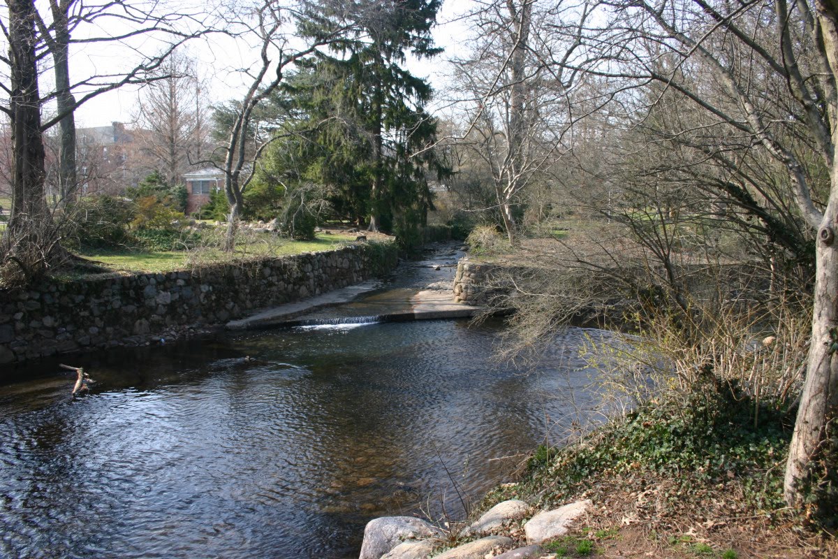
That's the Crooked Brook straight ahead, entering the East Branch, which flows right to left.
As we go upstream among the budding plants of early spring, we come to a wooden footbridge. The Maplewood Public Library is on the left.


As beautiful as it is, this is a managed stream with stone wall banks most of the way and a stone floor. As we round a bend in a wooded area we come to a portal.


Our task now is to determine the path of the Crooked Brook from here to the next place where it is above ground.
One thing that happens in the hidden depths is a fall that should have been enough to power a mill. I think I can hear it at the portal, but I am not sure. It's too bad we don't get to see it.
Now look at this thing. You can see it at the top of the previous photo.

Not far above the portal, at Dunnell Road, is a concrete barrier that would be pretty useful if there were something like a brook here. As it is, it protects pedestrians on the sidewalk from falling into a lawn.
I've seen this for years and I've laughed at it. But it's right on the course of the Crooked Brook if it continues straight on from the portal.
Here's the smoking gun! An aerial photograph from circa 1921 shows the Crooked Brook from its mouth right up to this concrete railing.

The park is in an early state here. The houses to the left of the Crooked Brook were later removed, and the half-built street you can see at lower right was obliterated. I don't know why a little more of the brook needed to be covered, relocating the portal such a short distance downstream.
But let's say it was necessary. The question is, why was the concrete railing left in place when the opening it protects was eliminated? You know why? It probably wasn't in the work order. You know how it is.
The map below is tiled together from Sanborn insurance maps dated 1912. We've come from the Rahway River on the right up to the portal at the street shown here as Oakland Road (now called Dunnell Road). The dashed line under the road has the label STONE CULVERT.

Beyond the railway, the Crooked Brook is no longer above ground.
Below, we have our backs to the railway, and we're looking upstream based on the location shown in the Sanborn map. The old post office to the left of the stream (shown in pink, for a brick building, with the lettering P O) was replaced by a one-story building of which the white-sided part is on the post office site and the green-painted part (Geralyn's Art Studio) is over the stream. Beyond, the faux half-timbered building is shown on the Sanborn map at the corner of Maplewood Avenue and Highland Place. The stream runs immediately to its right, therefore under the left side of the brick building (which houses St James's Gate pub on the ground floor).


Pulling back for the full view, we see an oddly angled piece of concrete at the bottom of the image. I think it's the remains of the portal on this side of the railway. The portal itself was probably under the concrete path we're standing on, which is partway up the railway embankment.
The railway embankment itself dates from a reconstruction project carried out in 1901-1903, which included construction of the present Maplewood station, the elimination of the Baker Street grade crossing, and widening of the line with a third track. The remains here and the useless barrier on the other side may date from that time. There was probably a simple bridge over the Crooked Brook before that.
Between the angled concrete and the green-painted building, there is a grating right in the middle of the parking lot that must be right over the brook. But it's a shallow drop, and I can't hear the brook running in it.
If we go around that block of buildings to their fronts on Maplewood Avenue, we find no trace of the brook.
But the STONE CULVERT shown on the Sanborn map is visible in the old postcard shown below. There's the old post office on the left, and just before it is a low wall with an iron fence on it. That's where the brook is. The same low wall and fence is on the right, too. The three-story building is not yet standing on the right, so this view is earlier than the 1912 Sanborn map.


Looking at the modern view, the location of the culvert was from where the pedestrian is walking, in front of Geralyn's Art Studio, to a spot between the Guinness sign and the American flag in front of St James's. The storm sewer next to the pedestrian must drain to the brook, but like the one in the parking lot it is shallow. The site is the lowest elevation on Maplewood Avenue.
From St James's, if you walk around the corner into Highland Place, and then walk up the first driveway between buildings, you end up in a small paved yard right behind St James's. It's private property but I think they won't mind too much.
Here's the Crooked Brook. Right there. That round grate. If you stand right next to it, you can hear the brook flowing down below and you can see the moving water in the darkness. This opening goes straight down the brook.

What a suspenseful moment! When will we see the brook again in the sparking sunlight? You'll just have to wait.
My photographs were taken on March 20 and 27, 2010. The aerial photograph is from Images of America / Maplewood by the Durand-Hedden House and Garden Association, Arcadia, 1998. The postcard of Maplewood Avenue is from Postcard History Series / Maplewood by John F Harvey, Arcadia, 2003. The Sanborn maps are from Insurance Maps of South Orange Village, including South Orange and Millburn Townships, New Jersey, by Sanborn Map Company, 1912, scanned by Princeton University.
Next time: Crooked Brook II.
No comments:
Post a Comment