This year I've been asked twice what I know about a very obscure local transit line, the elevated railway that once ran in Hoboken and Jersey City. Both people have created web pages I greatly recommend.
The first one is part of David Pirmann's nycsubway.org site, the Hoboken-Jersey City Elevated page. He has a good historical summary, and then a fine set of photographs he has assembled from contributors. Take a look.
Just recently someone told me to look at the New York Rapid Transit Timeline, a series of maps showing the rapid transit systems every 5 years from 1870 to 2010, and within a day I heard from its creator, Alexander Rapp. You should look at those too. They're really good. He wanted to include the Hoboken El but needed details.
The Hoboken El was operated in the same manner as the Green Line on the Boston T, the subway-surface lines in Philadelphia, and the Muni Metro in San Francisco, namely as a rapid transit line with street trolley lines running into it. Unlike those, and the City Subway in Newark, the Hoboken route was an elevated line, not a subway. If you look at Rapp's maps for 1935 to 1950, you'll notice he shows in pale color the street lines that ran into the Newark City Subway. I've just sent him details of the street routes for the Hoboken El.
There is a little mystery about this elevated line.
We know for sure, from contemporary newspaper and magazine sources, that it opened on January 25, 1886, running from a station adjacent to the Delaware, Lackawanna and Western Railroad's Hoboken Terminal to a station on the west side of Palisade Avenue, Jersey City, between Ravine Avenue and Ferry Street. The first part ran along Ferry Street (now Observer Highway) on a structure similar to elevated railways in Manhattan, but then it veered into private right of way up a long incline that rose about a hundred feet on a 5.5% grade to the top of the Palisades cliff. The cliff was the reason for building the line. The el provided the only fast route from the Heights neighborhood to a New York ferry connection, and soon carried 10,000 to 15,000 passengers a day.
The el was operated by cable. Management at the North Hudson County Railway were concerned about a runaway on the long grade. They used the Cable Trust patents developed for the San Francisco street cablecar lines, but with the thickest wire rope ever used, one and a half inches in diameter, and massive thousand-pound grips on both trucks. Company engineer J J Endres developed the patent grip with three-foot jaws controlled by a wheel at the ends of the car.
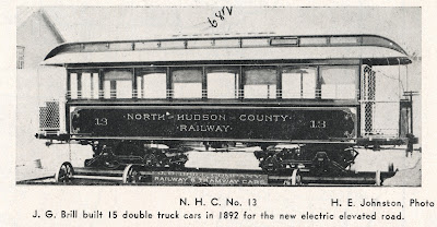
There were 14 cars similar in style to New York elevated railroad cars. Cable operation lasted seven years, but below is the only known photograph, and it seems to be just before the end, since support poles for trolley wires are already up. From the book Art Work of Jersey City, via George Hilton's book The Cable Car in America.
We also know for sure that the elevated railway was extended in 1892. The extension continued from the Palisade Avenue station over private right of way to a big curve, over Central Avenue from Booraem Avenue to Hoboken Avenue, and two more blocks of private right of way to a terminal at Pavonia Avenue.
Construction was underway by August 1890, when Scientific American described the both the structure and the plans for cable operation on it. Hilton writes that cable was installed by May 1891. But then the company decided not to operate it with cable. Instead the extension was opened on June 6, 1892 as an electric trolley road, connecting at Palisade Avenue with the cable road. Six months later electric service finally began running through to Hoboken.
A trip report published in May 1893 in Transit Journal says that the cable was still being used in rush hours. This was probably done to maintain separation between cars on the incline. It would mean a change of cars at Palisade Avenue was required just when traffic was busiest.
Here is where the mystery begins.
Modern writers assume that with electric operation, through service to street trolleys began. When I started looking into this for David Pirmann I found evidence to the contrary. Instead I am now convinced that for a while, the elevated still operated separately.
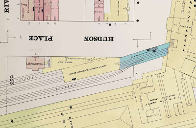
The first clue was two maps from a Sanborn real estate atlas of 1896, four years after the extension opened. Here's the smoking gun, a full terminal at Pavonia Avenue:
Later on, there was an incline down from the end of the Newark Avenue station to ground level at Lott Street, and tracks ran out to the street in Pavonia Avenue. But here, there is a real terminal, with two wooden (yellow) platforms and a station house across the end of track, and iron (blue) stairways. Please note that this is not a map of planned structures, but of buildings that actually existed.
Less obvious was the situation at Palisade Avenue:
There is a train yard with four sidings on the Ferry Street side, which was not there later on. That's because later on the equipment was stored and repaired at the same barns as other trolley lines. But at this date, evidently the el needed its own yard.
Here's one of the images from David Pirmann's page, a beautiful view from Pavonia Avenue looking down the right of way. Going back you can see the Lott Street crossing, the incline, and a trolley at Newark Avenue station. But what's that on the right?
Why, it's a column from the original elevated terminal! It's the strongest trolley wire support column in town.
Here's one more item, from "The North Hudson County Railway" by Edward T Francis and George W Walrath, in The Marker, September 1946. I include here their caption.
No steps.
That raises some questions. The original stations at Hoboken and Palisades Avenue would have had floor-height platforms, consistent with the use of structures and cars like those of the New York elevated lines. The car shown above is a hybrid trolley and elevated car. It's small and lightweight like a trolley, but the end platforms have gates. A note in the journal Electricity for December 21, 1892, says "the new cars have the double trolley and are smaller than the cable cars". Francis and George write that these were among the first two-pole trolley cars.
The 1896 atlas shows all of the small way stations. While the Pavonia Avenue terminal is of the same size as the old Hoboken and Palisades Avenue stations, the others are much smaller. They are shown in 1896 as short and wooden. Available photographs, mostly from the 1930s and 1940s, show the same, and the platforms are not much above rail level. Were the platforms really higher once?
The original Hoboken station had only one track while in cable service. As described in an 1886 issue of Scientific American, it was a typical cable terminal operation. The incoming car dropped rope 700 feet before the station (a fairly long distance), and ran by momentum, assisted by a slight downgrade, into the one station track. The cable itself continued without a track and around a sheave at the end and started running outbound under the one track, where the outbound car could grip it to leave. There were platforms on both sides of the track, for exit and entrance, and the article reports that the car or train could unload and load within one minute for fast turnaround.
The original Palisade Avenue station must have been similar in design.
A Sanborn atlas plate of 1891 for Hoboken shows an iron terminal with two tracks drawn in it, but the mechanics of cable operation force me to think it was still really only one track. Notice that the end of the iron structure connects directly into the ferry building. The great majority of riders would have been headed for the ferry. This terminal had high floor-level platforms.
My conclusion then is that the first stage electric operation in 1892 was an isolated trolley line running only on the elevated railway, with floor height platforms. This continued until at least 1896 when the available Sanborn atlas was surveyed.
You won't find this information anywhere else on the web, except in a sentence on David Pirmann's page, because I pointed out to him the Pavonia Avenue terminal map.
But how long did this last? When did through operation to street lines begin? And what about the platform height?
Some years ago, I looked at some Sanborn atlases in the Jersey City Public Library, and took photocopies of a set dated 1908 and 1909. They show the ramps. So it's before 1908.
Here's Hoboken, apparently not long after the railroad terminal burned down on August 7, 1905, showing the site of the elevated terminal. The ruins in the background are the site of the railroad terminal.
The trolley in the foreground is running on the Union Hill Line, and the one behind it is a Summit car. Both of those routes used the elevated line. So by late 1905, street lines ran on the el, and also, by this date, the small Hoboken terminal had been removed, and replaced by a street-level loop. I would guess both things happened around the same time, because more terminal space was needed.
I have narrowed the start of street lines on the el to a date between 1896 and 1905.
Three of the routes that ran on the elevated were North Hudson County Railway lines, namely the previously mentioned Union Hill and Summit lines, and the Oakland line. All of these left the structure at Palisade Avenue.
The fourth and last line however was the Jackson Line, the only one that ran to the end of the structure at Pavonia Avenue. Jackson, known as Court House until 1909, was not a North Hudson County property. Its corporate ownership remained separate until 1903, when its owners and NHC both were acquired by Public Service Railway. Was there through service before that?
Well, that's as far as I could get in one day. One of these days maybe I'll find something that narrows down that 1896-1905 gap. They had "Red Book" street guides to Jersey City and Hudson County later on, listing streetcar routes. I don't have one handy from before 1905. I never knew I needed one.
.


